


Wind advisory alerts spread coast to coast as powerful weekend storm ramps up
A fresh round of wind advisory alerts is rolling out across large parts of the U.S. heading into the weekend, with the strongest impacts expected along the Southeast and Mid-Atlantic coastline as a rapidly intensifying winter storm pushes north. Forecasters are highlighting a mix of dangerous crosswinds, scattered power-outage potential, and coastal flooding risk, with some communities facing high winds on top of extreme cold.
The timing matters: the worst conditions are expected Saturday into early Sunday in parts of the Southeast and southern Mid-Atlantic, then shifting toward coastal New England late Sunday into Monday. Even areas forecast to miss the heaviest snow are bracing for gusty conditions that can bring down limbs, complicate driving, and disrupt travel.
Wind advisory map expands ahead of weekend bomb cyclone
The broad wind footprint is being driven by a strengthening nor’easter expected to “bomb out” as it rides up the coast—an intensification that can tighten pressure gradients and accelerate winds far from the storm’s center. Along parts of the Outer Banks and nearby coastal zones, peak gusts have been projected into the 70–80 mph range, a level that can cause tree damage, scattered structural impacts, and longer-duration outages in exposed areas.
Farther north, the wind signal is also strong even where snowfall is lighter. Coastal Connecticut, for example, has been highlighted for gusts reaching about 45 mph from Saturday night into Sunday, paired with minor coastal flooding potential as high tides coincide with storm influence.
At the same time, the National Weather Service’s advisory mosaics show multiple wind headlines running along the Gulf Coast and into Louisiana, where colder air spilling south can keep winds brisk and make already-low temperatures feel even harsher.
Selected wind headlines and timing (ET)
| Area | Timing (ET) | Peak winds/gusts highlighted |
|---|---|---|
| Outer Banks/coastal Mid-Atlantic | Sat night–early Sun | Gusts projected 70–80 mph in hardest-hit coastal zones |
| Coastal Connecticut/Long Island region | Sat night–Sun | Gusts up to ~45 mph in coastal areas |
| Coastal Gulf County, Florida | Sat 1:00 a.m.–Sun 10:00 a.m. | NW 15–25 mph, gusts up to 40 mph |
| Parts of southwest/central Louisiana | Sat daytime (local advisory windows vary) | North winds near 20 mph, gusts up to 30 mph |
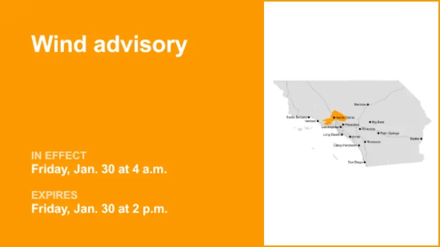
| Santa Clarita Valley & nearby SoCal corridors | Fri morning–2:00 p.m. | NE 15–25 mph; gusts to 35 mph common; local 45 mph in hills/mountains |
Snow may miss some cities, but winds won’t
A defining feature of this setup is that wind impacts extend well outside the bullseye of heavy snow. Even places expected to avoid major accumulation can see hazardous driving—especially for high-profile vehicles—because strong gusts can turn bridges, elevated roadways, and open stretches into white-knuckle runs.
For coastal communities, wind direction matters as much as speed. Onshore flow can pile water into vulnerable bays and inlets, while strong coastal gusts can produce wave run-up that worsens flooding during high-tide cycles. Offshore flow can limit surge in some spots but still generate damaging gusts and rough marine conditions.
Florida’s Gulf Coast faces wind plus extreme cold
Along Florida’s Panhandle coastline, the weekend setup is unusual for the combination of hazards arriving together: brisk northwest winds, hard-freeze concerns, and dangerous wind chills for a region not built for prolonged cold snaps.
One advisory zone along Coastal Gulf County calls for northwest winds of 15–25 mph with gusts up to 40 mph from early Saturday through Sunday morning. That window overlaps with a sharp temperature drop, increasing the risk to people outdoors for long periods, as well as to pipes, plants, and pets—especially in more exposed coastal areas where wind can be relentless overnight.
Southern California: strong canyon and corridor gusts
While the East Coast storm drives the biggest national headline, wind hazards are also active in Southern California. An advisory from the Los Angeles/Oxnard forecast office covers the Santa Clarita Valley, the Santa Susana Mountains, parts of Ventura County valleys, and the Highway 14 corridor through early Friday afternoon.
In that zone, northeast winds of 15–25 mph are expected with gusts to 35 mph common, and localized gusts up to 45 mph in the hills and mountains. That’s enough to topple unsecured outdoor items, snap weaker branches, and make driving difficult for trucks and vans—particularly on wind-prone passes and along canyon exits.
What to watch through Sunday: outages, travel, and marine impacts
The most immediate practical risks are power disruptions and travel complications. Strong gusts can bring down limbs onto lines, and sustained winds can delay repairs. If you’re traveling, crosswinds and rapidly changing conditions near the coast can be more dangerous than total snowfall amounts suggest.
Marine conditions are also a major concern. Forecast briefings along parts of the Carolinas have highlighted gale-force winds over coastal waters late Saturday into Sunday, with the potential for even stronger bursts near the most exposed stretches of coastline.
Looking ahead, the key pivot points are the storm’s track and how quickly it deepens. A small shift offshore can change who gets blizzard conditions versus mainly wind, while still keeping coastal flooding and outage risk elevated in vulnerable areas.
Sources consulted: National Weather Service; NOAA; The Washington Post; CT Insider; NASA Earth Observatory


