


Forecasters Track East Coast Storm Amid Ongoing Severe Cold
Forecasters are closely monitoring a winter storm that is expected to impact the East Coast this weekend. This comes on the heels of a previous powerful storm that left significant snow and ice across large portions of the United States. As a result, many areas have been grappling with lingering effects alongside an influx of Arctic air from Canada, leading to unseasonably low temperatures.
Potential Storm Developments
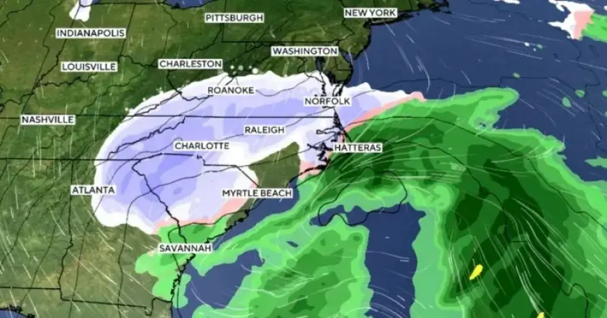
The National Weather Service projects that another Arctic blast will arrive Thursday night, bringing additional cold air. Concurrently, meteorologists are tracking a low-pressure system forming off the Carolina coast. This storm is forecasted to enter the East Coast, although its exact impact remains uncertain.
Storm Track Predictions
- Two primary forecast models exist: the European model and the U.S. model.
- The European model suggests minimal land interaction, while the U.S. model indicates a potential shift toward the west.
If the storm tracks westward, regions in the Northeast could experience more wintry weather. Conversely, if it stays farther offshore, snowfall may primarily affect coastal areas.
Winter Storm Warnings
Winter storm warnings have been issued for a number of states, including:
- North Carolina
- Virginia
- Georgia
- Illinois
- Tennessee
- West Virginia
- Massachusetts
Forecasters predict heavy snowfall in Virginia and the Carolinas, with isolated totals reaching up to 16 inches. Severe wind gusts also pose a threat, with some areas experiencing gusts nearing 65 mph.
Record Lows and Extreme Cold Conditions
The arrival of Arctic air will contribute to dangerously low temperatures throughout the eastern United States. Significant temperature drops are expected in major cities:
- New York City: Approximately 4°F
- Newark, NJ: Around 3°F
- Pittsburgh: Estimated low of -8°F
- Buffalo: Projected to reach -5°F
These temperatures could break long-standing records, some dating back to the 1930s and 1940s. Wind chills will further exacerbate cold conditions, dropping temperatures well below zero.
Possible Bomb Cyclone Formation
Meteorologists have raised the possibility of a “bomb cyclone” developing if the storm intensifies rapidly. This phenomenon, known as “bombogenesis,” occurs when a storm’s pressure drops significantly. While not guaranteed, the indicators suggest an increased likelihood of this event, particularly if the storm tracks offshore, minimizing land interaction.
As the weekend approaches, the East Coast braces for potential impacts from this winter storm. Residents are advised to prepare for severe weather conditions that could disrupt travel and daily activities.