


Russia snow crisis: Kamchatka buried under record drifts as winter blast disrupts travel across the region
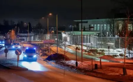
Russia snow has become a global talking point this week after an intense run of Pacific-driven storms buried parts of the Far East—especially Kamchatka—under towering drifts, trapping residents, disrupting transport, and prompting emergency measures. While images from Petropavlovsk-Kamchatsky have dominated social media, the wider cold surge has also rippled across Northeast Asia, affecting flights, roads, and daily life far beyond Russia’s borders.
The immediate situation is twofold: crews in Kamchatka are still digging out neighbourhoods and clearing roofs after dangerous accumulations, while travellers across the region are dealing with delays and closures as the winter pattern stays volatile.
-
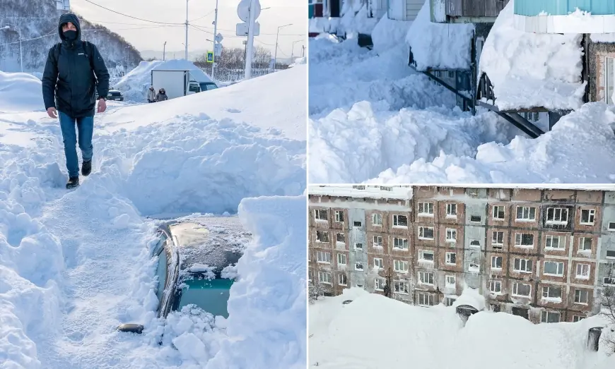
Kamchatka’s capital, Petropavlovsk-Kamchatsky, has faced extraordinary snow depth, with drifts blocking entrances and burying vehicles.
-
Fatal incidents linked to roof snow/ice highlight why authorities focus first on structural and public-safety hazards, not just road clearance.
-
Transport disruption has been a defining feature—flight delays, road closures, and slower emergency response times during peak accumulation.
-
Officials have activated emergency-style responses in affected areas as clearance becomes a multi-day operation rather than a single storm cleanup.
-
A wave of misleading or manipulated “snow apocalypse” clips has circulated online, making official advisories and verified local updates more important than viral video.
Russia snow in Kamchatka: what’s happening on the ground
The epicenter of the most dramatic scenes has been Kamchatka, a rugged peninsula where powerful winter cyclones can funnel moisture and wind into extreme snowfall. In Petropavlovsk-Kamchatsky, residents have described doorways sealed by snow walls, cars disappearing under compacted drifts, and normal movement turning into an obstacle course of tunnels and shovel work.
The biggest challenge isn’t simply the depth—it’s the combination of wind-driven piling, repeated bursts of heavy snow, and the time it takes to restore basic mobility. When roads can be cleared once, then rapidly refill, the priority shifts to keeping main routes open for ambulances, supply runs, and critical infrastructure.
Roof management has also become a life-and-death issue. In heavy-snow climates, a storm’s danger often peaks after the flakes stop falling—when warming, wind, and vibration loosen dense slabs of snow and ice that can slide or drop without warning.
How the winter blast is disrupting travel beyond Russia
This Russia snow story isn’t isolated. The broader cold snap and storm track have hit transportation networks across the region, including flight disruptions and road closures that can cascade quickly in winter conditions. When airports operate with intermittent runway clearing and de-icing bottlenecks, schedules can unravel for days—especially on routes with fewer alternative flights.
For travelers, the practical impacts tend to look like this:
-
Delayed departures and missed connections as aircraft rotation breaks down
-
Short-notice cancellations when crews hit duty-time limits
-
Longer ground travel times as secondary roads remain impassable even after main arteries reopen
-
Supply delays as trucking slows and ports/rail nodes work through backlogs
If you’re planning travel connected to Russia’s Far East in the near term, the key is flexibility: expect short-notice changes, keep essentials in carry-on, and confirm ground transfers before committing to tight connections.
Why this Russia snow event feels so extreme
Kamchatka is no stranger to heavy winter weather, but the current episode stands out because of cumulative totals and repeated impacts. When snowfall arrives in concentrated bursts over a short period, cities can run out of “storage capacity”—there’s simply nowhere left to push the snow without hauling it away, which takes time, fuel, and machinery.
It also stresses the hidden systems that keep cities functioning:
-
Power and communications (lines weighed down by ice and wind)
-
Emergency access (narrowed streets and blocked lanes)
-
Water and drainage (freeze-thaw cycles and clogged channels)
-
Building safety (roof load and ice fall hazards)
A useful historical context: in the months leading into mid-winter, Kamchatka and other Far Eastern regions can see compounding storms where one major event sets the stage for the next. When December snowpack is already deep, January storms don’t just add snow—they raise the baseline risk for roof incidents, vehicle entrapment, and multi-day recovery operations.
What residents and visitors should do next
For locals in affected zones, the most important safety behavior is often the least dramatic:
-
Avoid walking close to building edges where snow/ice can fall from roofs
-
Respect cordons around schools, apartment blocks, and steep embankments
-
Treat “cleared” areas as temporary—drifts can rebuild quickly with wind
-
Keep phones charged and plan for slower emergency response times during peak clearing
For visitors (or anyone sharing clips online), there’s another priority: verification. Extreme-weather events attract manipulated videos and mislabeled footage. The safest approach is to rely on official alerts, confirmed local announcements, and time-stamped updates—not the most sensational clip.
FAQ
Where is the worst Russia snow right now?
The most severe accumulations and disruption have been concentrated in Russia’s Far East, particularly Kamchatka and the Petropavlovsk-Kamchatsky area.
Why is Kamchatka getting so much snow?
A storm track bringing moisture-laden systems across the North Pacific can produce intense snowfall when cold air, wind, and terrain combine—creating deep drifts and repeated bursts of accumulation.
Is it safe to travel during the Russia snow disruptions?
It can be, but expect delays and sudden changes. Check flight status frequently, build buffer time, and plan for ground-transport slowdowns.
What happens next depends on the storm track and temperatures. If the pattern relaxes, the story shifts from “snowfall totals” to “cleanup and safety”—roof clearing, reopening secondary roads, and restoring normal schedules. If another system follows quickly, the risk rises again, not just for travel disruption but for structural hazards in areas where snow has already stacked up for weeks.