


Arctic Blast to Bring Dangerous Wind Chills and Possible Snow to N.J. Tonight
New Jersey is bracing for a significant drop in temperatures and adverse weather conditions. An Arctic blast will bring dangerously low wind chills and potential snowfall to the region. This weather event is expected to occur from Monday night through Tuesday morning, posing risks for frostbite and hypothermia.
Cold Weather Alerts Issued
The National Weather Service has issued cold weather alerts for eight counties in New Jersey:
- Hunterdon
- Mercer
- Middlesex
- Monmouth
- Morris
- Somerset
- Sussex
- Warren
These alerts will be active from 2 a.m. to 10 a.m. on Tuesday, warning residents of wind chill temperatures that could drop as low as zero degrees. In some northern and western parts of the state, temperatures may even fall below zero.
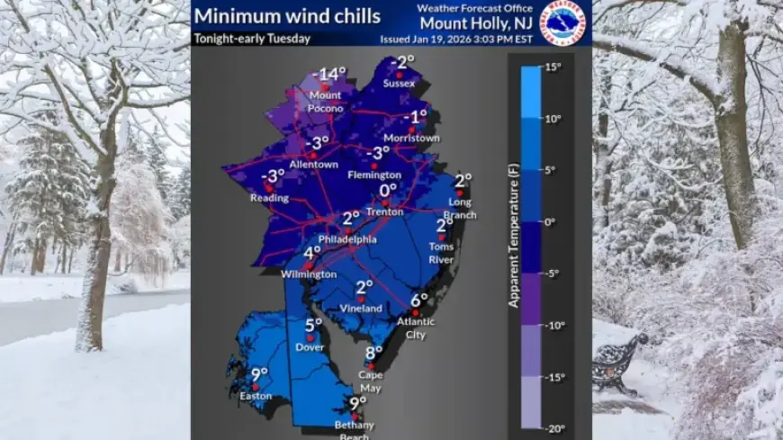
Wind Chill and Temperature Forecast
Wind chill readings across New Jersey are expected to plunge into the single digits overnight. Areas northwest of the Interstate 95 corridor could experience wind chills near or below zero degrees. Combined weather conditions include:
- Temperatures in the single digits and teens
- West-northwest winds gusting up to 30 mph
Travel Advisory
Residents are advised to exercise caution when traveling. Monday’s daytime snowmelt may refreeze overnight, leading to the formation of black ice. The National Weather Service recommends allowing extra time for commutes and dressing in appropriate layers if exposed to the elements.
Upcoming Weather Patterns
The biting cold is forecasted to persist through Wednesday. High temperatures on Tuesday will only reach the lower 20s, with wind chills remaining in the single digits. A brief reprieve from the cold is expected on Wednesday, with temperatures rising into the 30s.
Potential Winter Storm
Forecasters are monitoring a low-pressure system projected to develop over the Southern Plains by Friday. This system could affect parts of New Jersey over the weekend. However, there is considerable uncertainty regarding its track. The outcomes depend significantly on the strength of an Arctic high-pressure system to the north. Key probabilities noted include:
- 40% to 60% chance of receiving 2 or more inches of snow
- 20% to 40% chance of 6 or more inches of snow in areas south of Philadelphia
Residents are encouraged to stay updated for further details as forecasters refine their predictions for the weekend storm. For the latest updates, continue checking Filmogaz.com.