


Winter Storm Fern Forecast Track: Where the Storm Is Headed, Timing by Day, and the Biggest Ice vs. Snow Risk Areas
Winter Storm Fern is shaping up as a broad, high-impact winter system that could stretch from the Southern Plains into the Southeast and parts of the East this weekend, with the most disruptive impacts hinging on one key detail: how quickly cold Arctic air locks in at the surface while moisture surges north. The result could be a classic Southern winter hazard—freezing rain and sleet—alongside a swath of heavy snow on the colder, northern side of the track.
Forecast confidence is rising that a significant storm develops, but the exact placement of the “ice corridor” still has meaningful wiggle room. Small shifts in the storm track and temperature profile can flip communities from rain to glaze ice, or from sleet to snow.
Winter Storm Fern Forecast Track: The Big Picture Setup Driving This Storm
Fern’s potential comes from a powerful overlap:
-
A deep push of Arctic air sliding south and east
-
A slow-moving storm system feeding moisture out of the Gulf and Pacific
-
A storm track that favors a long, west-to-east run across the southern tier of the U.S.
This combination is notorious for producing mixed precipitation. In many places, the atmosphere can be below freezing near the ground while a thin “warm layer” aloft turns snow into rain—then the drops refreeze on contact. That is how damaging ice storms form.
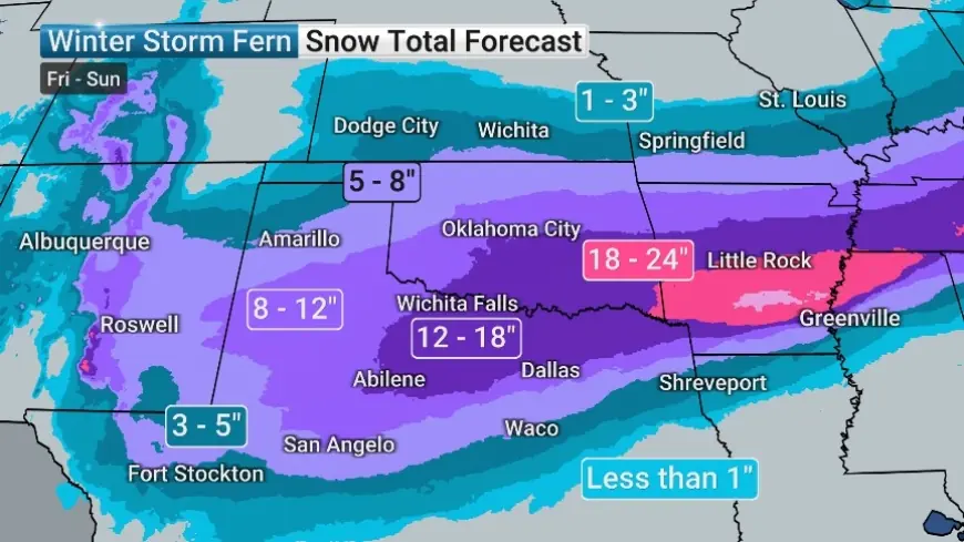
Track and Timing: When Winter Storm Fern Arrives in Each Region
Below is a practical, planning-style timeline. Exact hours will vary by location and will tighten up inside the 24–72 hour window.
-
Friday, Jan. 23 (late day into night): Wintry precipitation begins to expand across parts of the Southern Plains and into areas of Texas and Oklahoma, especially north and west of the warmest air.
-
Saturday, Jan. 24: The storm spreads east. Icing and sleet risks grow across portions of the Deep South while colder inland areas trend toward snow or sleet.
-
Sunday, Jan. 25: Impacts continue farther east, with parts of the Southeast and interior Mid-Atlantic potentially dealing with lingering ice/snow and travel disruptions.
-
Behind the storm: A fresh surge of frigid air increases refreeze risk and can extend hazardous conditions even after precipitation ends.
Ice vs. Snow: The Most Likely Impact Zones Right Now
Forecast signals increasingly favor a meaningful icing threat somewhere in the South, with snow more likely on the northern flank. The dividing line is still shifting.
Highest concern: Freezing rain and damaging ice
-
Portions of Texas into the Southern Plains
-
Parts of the Deep South, including areas that may sit below freezing for extended stretches
-
Potential expansion toward the Carolinas and interior Southeast as the system moves east
Ice is the impact that brings the most “outsized” damage: power lines and tree limbs become vulnerable, and road travel can deteriorate rapidly even with light precipitation.
Greater snow potential: Colder interior zones north of the main ice band
-
Portions of the Tennessee Valley and adjacent higher terrain
-
Some areas of the southern Appalachians and nearby inland regions
-
Interior sections farther northeast where cold air holds longer
A modest shift in track can widen or narrow this snow swath significantly.
Why Forecasts Still Look “Unsettled” for Fern
Winter storms in the South often remain uncertain until closer to arrival because precipitation type depends on fine temperature details—sometimes differences of just 1–3°F near the surface or a shallow warm layer a few thousand feet up.
Two details matter most:
-
Storm track of the surface low: Farther north can mean more warm air and a bigger ice threat; farther south can push heavier snow and sleet farther south.
-
Strength and placement of the cold high pressure to the north: A better “cold air supply line” can keep temperatures below freezing longer, increasing ice risk and making accumulations more likely to stick.
What This Means for Travel, Power, and School Decisions
If Fern verifies with a significant icing corridor, impacts tend to stack quickly:
-
Road conditions: Bridges and overpasses ice first, then untreated roads. Once glaze forms, travel becomes dangerous even with small accumulations.
-
Power outages: Ice loading on trees and lines can create scattered to widespread outages, especially where freezing rain persists for hours.
-
Closures and delays: Districts often wait for higher confidence, but prolonged subfreezing temps plus overnight icing frequently lead to late calls and next-day cancellations.
What to Do Now While the Track Is Still Shifting
-
Build plans around impact type, not just totals: ice changes everything.
-
Prep for refreeze after the precipitation ends: hazards can linger into Monday morning in colder pockets.
-
Charge devices, check flashlights, and stage basics in case of outages (especially in ice-prone areas).
-
If travel is optional this weekend, consider moving plans earlier or later.
Winter Storm Fern’s forecast track is coming into better focus: a long-duration storm crossing the Southern U.S. late Friday into Sunday, with the most serious risk centered on where freezing rain sets up. The next round of updates should sharpen the placement of the ice band and clarify which cities end up on the snow side versus the glaze side.


