


Weather Warnings Ireland: Land Stays Green but Marine Alerts Turn Yellow as Gales Target Irish Sea Coasts
Ireland enters the middle of the week with a split message from the warning system: weather warnings in Ireland remain Green on land, but marine warnings are Yellow as stronger winds and rough seas build around the coast. The practical impact is clear even without county-level land alerts: conditions at sea and along exposed shorelines can deteriorate quickly, and travel disruption tends to show up first on ferry routes, coastal roads, and harbours.
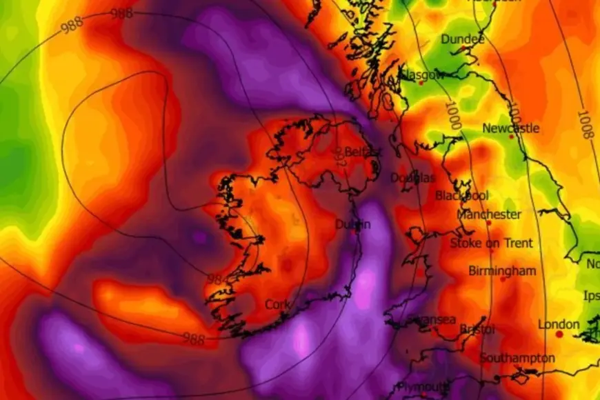
For Wednesday, January 21, the focus is on the Irish Sea, where gale-force gusts are timed to sweep northward through the day, while a longer-running small craft alert continues for all coasts.
Weather warnings Ireland today: No land warning, but a coastal risk window
The national warning page for the Republic of Ireland shows no active land weather warnings (Green). That does not mean “no hazards,” especially in a changeable Atlantic pattern. It does mean forecasters do not currently expect impacts to reach the threshold that triggers county-based Yellow, Orange, or Red alerts for inland areas.
The sharper risk is marine and coastal, where stronger winds can combine with high tides and wave action to produce short-notice local problems such as spray, overtopping near sea walls, and difficult driving for high-sided vehicles on exposed routes.
Marine warnings: Yellow small craft alert on all coasts
A Status Yellow small craft warning remains in place for all coasts of Ireland, highlighting periods when winds reach force 6 or higher. This is the “background” warning that covers a multi-day stretch and is aimed at smaller vessels and anyone planning near-shore operations.
Key window:
-
Valid: 20:00 Monday 19 January to 00:00 Thursday 22 January (times in local winter time)
For coastal communities, this is the type of warning that often translates into choppier crossings, uncomfortable conditions on open decks, and elevated risk for recreational boating, paddle sports, and cliff paths.
Gale warnings: Two timed Yellow alerts for Irish Sea sectors
Within that broader small-craft period, two separate Yellow gale warnings outline a more concentrated threat from east to southeast winds reaching gale force 8 at times. The sequence matters because it shows the strongest conditions shifting north through the day.
Wednesday, January 21:
-
05:00 to 13:00: Gale conditions highlighted for the south Irish Sea and a southern/eastern coastal sector running from Howth Head to Hook Head to Valentia.
-
13:00 to 23:00: Gale conditions then extend to the north Irish Sea, flagged for the coastal arc from Malin Head to Belfast Lough to Howth Head.
In plain terms: if you’re on the water or planning coastal travel, the “worst window” is likely to arrive earlier along parts of the east and southeast, then push north later in the day.
What this means for ferries, ports, and coastal travel
Even when land warnings are Green, marine Yellow alerts frequently bring knock-on effects:
-
Ferries: Operators may alter timetables, switch to larger vessels where possible, or adjust routes for safety and comfort.
-
Ports and harbours: Smaller craft movements can be restricted; berthing can become more challenging in crosswinds.
-
Coastal roads: Sudden gusts and sea spray can reduce visibility, especially near headlands and causeways.
-
Wave overtopping risk: Exposed promenades, piers, and sea walls can become dangerous quickly during gust peaks and higher tides.
The most important behavior change is avoiding “quick checks” near the water during the peak wind window. Wave impacts can reach farther than expected, and conditions can change in minutes.
Northern Ireland: Check local messaging, but no obvious warning signal in the region
Across the border, the UK warning map shows Yellow warnings in parts of the wider UK midweek, largely tied to persistent heavy rain over hills in Scotland. Northern Ireland’s regional forecast highlights windy conditions and bands of rain, but it does not present the same warning emphasis as areas farther east and north. As always, the safest approach is location-specific checks before longer drives, hikes, or coastal plans.
What to watch next: How quickly warnings can change
This week’s setup is the type that can shift warning levels quickly if the track of wind and rain bands moves even slightly. Three triggers often lead to upgrades:
-
Stronger gust potential than first expected along the Irish Sea coast
-
Heavier rain bands aligning with saturated ground
-
Wave impacts increasing around high tide on exposed shorelines
For now, the headline remains: weather warnings Ireland are Green for land, but marine conditions are under Yellow alerts, with timed gale windows making Wednesday the day to take coastal caution most seriously.