


Raleigh Weather Turns Risky: Black Ice Concerns Now, Then a Stronger Winter Storm Signal for Jan. 24–25
Raleigh weather is moving from clear, biting cold into a more complicated stretch that could affect driving and weekend plans. The immediate issue is overnight refreezing that can leave slick spots on untreated roads early in the day. The bigger headline is a strengthening signal for wintry precipitation around Saturday, January 24 into Sunday, January 25, when rain could transition to snow, sleet, or freezing rain depending on how temperatures line up.
While the exact mix and totals are still coming into focus, the pattern favors at least some travel disruption potential, especially during the coldest hours.
Raleigh Weather Right Now: Cold Nights, Hidden Ice Risk
Even without fresh precipitation, Raleigh can run into trouble when temperatures dip below freezing after a damp day or melting frost. Bridges, overpasses, and shaded secondary roads cool faster than main roads, which is why “it looked fine” can turn into a sudden slide at 6 a.m.
What to watch each morning this week:
-
A thin glaze on windshields and sidewalks
-
Wet-looking pavement that is actually frozen
-
Icy patches on ramps and elevated roads
If you’re commuting early, slow down before turns and braking zones, and give extra space to the car ahead. For walking, treat parking lots and building entrances as higher-risk than open sidewalks.
The Midweek Setup: Brief Milder Stretch, Then Clouds Return
Raleigh weather should feel less harsh during the day midweek as afternoon temperatures climb, but nights remain cold enough to keep refreezing in play. Expect a mix of sun and clouds, with a gradual increase in moisture later in the week.
This matters because “milder” afternoons can melt leftover frost or light wintry residue, then the drop after sunset can refreeze that same moisture into slick patches. It’s a classic Raleigh winter problem: not always dramatic, but often sneaky.
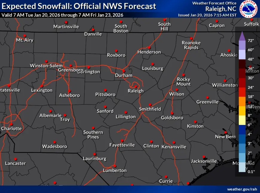
Weekend Watch: Winter Storm Potential Peaks Jan. 24–25
The most consequential window is shaping up from Saturday into early Sunday. Forecast guidance has been trending toward a more organized winter system affecting parts of the Southeast, with central North Carolina in the zone where small temperature differences decide the outcome.
Here are the most plausible scenarios for Raleigh weather over the weekend:
-
Cold rain turning wintry at night: Rain Saturday could change to sleet or snow as colder air deepens.
-
Freezing rain risk: If surface temperatures hover at or below 32°F while warmer air rides above, ice becomes possible.
-
Mostly snow: If cold air is strong enough through the lower atmosphere, snow becomes the main type, especially late Saturday into Sunday.
Key point: the “changeover” timing is often what drives impact. A shift of just a few hours can mean mostly wet roads, or a period of icing that makes driving hazardous.
Practical Timeline: When Impacts Are Most Likely
A simple planning view (subject to change as the forecast tightens):
-
Friday, January 23: Increasing clouds and scattered precipitation possible. Roads mainly wet, but nighttime cooling starts to matter.
-
Saturday, January 24 (daytime): Periods of rain or mixed precipitation possible; watch temperatures closely.
-
Saturday night into early Sunday, January 25: Highest risk for slick travel if temperatures fall near or below freezing.
-
Sunday, January 25 (later): Precipitation may taper, but cold air can keep any leftover moisture frozen.
What to Do Now: Prep That Actually Helps
You don’t need to overreact, but a few basics make a real difference in Raleigh weather events:
-
Driving: Keep your gas tank at least half full. Check tire tread. Confirm your windshield washer fluid is winter-rated.
-
Home: Cover exposed outdoor spigots, and let faucets drip slightly overnight if temperatures drop sharply.
-
Errands: Shift groceries and pharmacy runs earlier in the day Saturday rather than late Saturday night or early Sunday.
-
Work/school planning: If you can, build flexibility into Sunday morning schedules in case roads become slick.
What’s Next for Raleigh Weather
The forecast is likely to sharpen in the next 24–48 hours as the weekend system’s track and temperature profile become clearer. The main questions are: how cold the surface layer gets in the Triangle, how quickly colder air arrives, and how long precipitation overlaps with subfreezing temperatures.
For now, treat this as a two-part story: cautious mornings for black ice in the near term, then a meaningful winter-weather threat that could peak late Saturday into early Sunday.