


Sunny Skies in Pittsburgh Today; Storms Expected Tomorrow
Forecast summary: Sunny Skies in Pittsburgh Today; Storms Expected Tomorrow. The day will be pleasant with abundant sunshine. Storm chances return to the region on Saturday.
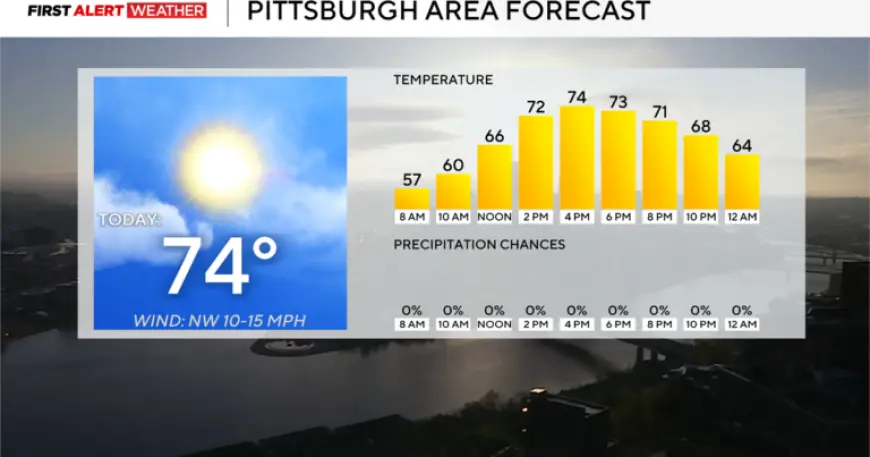
Current temperature trends
Temperatures this month are running 10.7° above the long-term average. The area is on pace for the warmest April on record.
Compared with the hottest April in local records, readings are about 2° higher so far. The KDKA Weather Center provided these observations.
Today’s conditions
Highs will reach the mid-70s. Noon readings are forecast near 66°.
Winds will be light from the northwest at about 5 mph. The average high for this date is 63°, with an average low of 41°.
Severe weather outlook for Saturday
A cold front will bring storm chances starting early Saturday afternoon. The greatest activity is expected in the early to mid-afternoon period.
After roughly 7 p.m., the threat will shift to mainly rain showers. The Storm Prediction Center has placed the area at level 2 of 5 for severe storm risk.
Primary hazards
- Strong straight-line winds.
- Heavy downpours and frequent lightning.
- Large hail possible.
- Tornadoes cannot be ruled out.
Early week outlook
Cooler conditions will arrive briefly next week. Both Monday and Tuesday mornings could see temperatures near or below freezing.
Model guidance indicates a chance for a few snow showers Monday morning. Warmer air should return by Tuesday afternoon, pushing temperatures back above normal.
Reporting and analysis by Filmogaz.com, with data from the KDKA Weather Center and the Storm Prediction Center.