


Severe Storms Likely Saturday Afternoon: 19 First Alert Weather Warning
A strong cold front will cross Northeast Ohio on Saturday afternoon. Meteorologists have issued a 19 First Alert weather warning as severe storms are likely on Saturday afternoon.
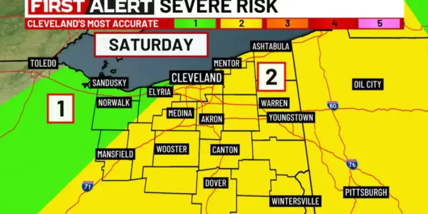
The greatest severe risk will be east of I-71 between noon and 5 p.m. Heavy rain and damaging wind gusts are the primary hazards.
A line of showers and thunderstorms will move in from the west during the late morning. Storms should strengthen as they push east and depart the region after 5 p.m.
Timing and areas at risk
By sunrise on Saturday, a few showers may already move through, but the severe risk will be low early. The window of highest concern runs from midday into the late afternoon.
Main threats
Threats include heavy rainfall and strong, damaging wind gusts. A cell or two could produce quarter-sized hail or a brief tornado.
- Heavy rainfall leading to brief downpours.
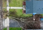
- Damaging wind gusts capable of tree or power damage.
- Localized quarter-size hail possible.
- Brief tornado cannot be ruled out.
Short-term forecast
Friday will be pleasant with abundant sunshine and no rain expected. A northerly breeze will keep highs in the upper 60s to around 70 near the lakeshore, and mid to upper 70s farther south.
Overnight lows on Friday should fall to near 60 under mostly cloudy skies. By Saturday morning, scattered showers may already be moving across the area.
Weekend and early-week outlook
Behind the cold front, Sunday will turn much cooler. Low temperatures will drop into the 30s Sunday morning, with afternoon highs only in the upper 40s.
It will be windy on Sunday, with scattered lake-effect showers developing later in the day. Some wet snow could mix in as temperatures fall toward freezing Monday morning.
Monday afternoon should be partly cloudy with readings in the 40s. Warmer air returns on Tuesday, with afternoon highs reaching the 60s.
A generally quieter week is expected, with the next organized chance for rain not arriving until the following Saturday. Stay tuned to local forecasts for updates from Filmogaz.com and take the 19 First Alert status seriously if you are east of I-71.