


Tornado Watch Issued for Oklahoma, Including OKC Metro, Amid Storm Risk
A tornado watch is in effect across large parts of Oklahoma until 11 p.m. Tuesday, April 14, 2026. Filmogaz.com reports the watch includes the OKC metro as storms carry a heightened storm risk.
Immediate warnings and hazards
A severe thunderstorm warning was in place at 6 p.m. for a storm from north of Foss to northwest of Willow. That storm was warned for ping-pong-ball-sized hail and 60 mph winds.
Areas near Canute and Strafford faced the highest hail threat. Additional warnings covered parts of southern Oklahoma, including Stephens and Cotton counties, through 6:30 p.m.
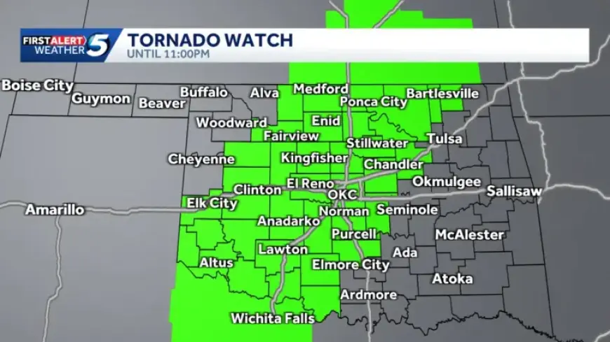
Counties under the tornado watch
The watch covers numerous central, northern and southwestern counties until 11 p.m. Local officials advise residents to monitor conditions closely.
- Alfalfa, Beckham, Blaine, Caddo, Canadian
- Cleveland, Comanche, Cotton, Creek, Custer
- Dewey, Garfield, Garvin, Grady, Grant
- Greer, Harmon, Jackson, Jefferson, Kay
- Kingfisher, Kiowa, Lincoln, Logan, Major
- McClain, Noble, Nowata, Oklahoma, Osage
- Pawnee, Payne, Pottawatomie, Stephens, Tillman
- Washington, Washita
Risk levels and expected impacts
The National Weather Service upgraded part of the state to a level 3 enhanced risk. That zone runs from southwestern through central into north-central Oklahoma.
Surrounding areas were placed at level 2 slight risk. Northwestern and southeastern counties carried a level 1 marginal risk.
Rotating supercells are possible. The highest tornado risk sits in southwestern and west-central Oklahoma.
Tornado index and areas of concern
The tornado index reached 6 out of 10 west of Oklahoma City. Towns included in that higher index were Hobart, El Reno, Chickasha, and Lawton.
Nearby areas, including parts of the OKC metro and northern Oklahoma, held an index of 4 out of 10. Risk declines farther northwest and east.
Hail potential
Hail sizes were upgraded across central, southwestern, and north-central Oklahoma. Some cities could see softball-sized hail.
- Softball-sized hail possible in OKC, Norman, Chickasha, Lawton, Altus
- Also possible in Hobart, Clinton, Watonga, Guthrie, Stillwater
- Enid, Ponca City, Medford, and Fairview also listed for large hail
- Other central, southwestern, and northern areas could see golf-ball hail
Storm timeline and what to expect tonight
Storms were expected to develop in western Oklahoma as early as 3 p.m. They were forecast to move into central Oklahoma and the OKC metro between 6 and 9 p.m.
Activity was forecast to push into east-central Oklahoma after 9 p.m. and reach far eastern counties after midnight. There was a low chance the dryline could refire in western Oklahoma later Tuesday night.
Outlook for Wednesday
Severe weather risk continues on Wednesday with a level 2 slight risk across much of the state. Storms could again produce large hail, damaging winds, and tornadoes.
The tornado index for Wednesday was pegged at 4 out of 10 for areas near Lawton, Hobart, Oklahoma City, Seminole, Stillwater, Enid, and Bartlesville.
Safety guidance and updates
Residents should take the Tornado Watch seriously and prepare to seek shelter if warnings are issued. Keep a battery-powered radio or weather app handy for alerts.
Filmogaz.com will provide continuous updates from Chief Meteorologist Damon Lane. Monitor local guidance and emergency notices as conditions evolve.