


Cooler, Wetter Weather Returns This Week
A strong cold front will sweep through Nebraska early Tuesday. Forecasters warn of gusty winds, falling temperatures, and two separate rain events over several days.
Tuesday — Cold Front and Strong Winds
The front arrives around sunrise Tuesday. Northwest wind gusts could reach 35 to 45 mph, with occasional stronger gusts possible.
Winds should ease to 25–35 mph by afternoon but remain breezy. Highs will vary across the state, with readings in the 40s, 50s, and 60s from northwest to southeast.
Wednesday — First Round of Rain
Rain begins light and scattered Wednesday morning. It becomes more widespread by afternoon and lingers into Thursday morning.
Expect chilly highs in the 40s and east-northeast winds of 10–20 mph. Eastern and southeastern Nebraska could see a few rumbles of thunder.
Northern counties may experience brief mixing with light snow overnight. Ground temperatures should prevent accumulation or travel impacts.
Thursday — Brief Break
Thursday evening brings a short respite from precipitation. Temperatures climb slightly but remain below seasonal averages.
Daytime highs will once again range across the 40s, 50s, and 60s statewide. Use Thursday’s dry window for outdoor tasks.
Friday–Saturday — Second System
A second rain system moves in Friday. Rain starts scattered in the morning and becomes widespread by afternoon.
This system pushes eastward Friday night into Saturday. Northern parts of the state could see a mix of light snow with stronger northwest winds following the system.
Most locations will reach highs from the upper 30s to the upper 50s on Friday. Cooler, windy conditions are expected into Saturday.
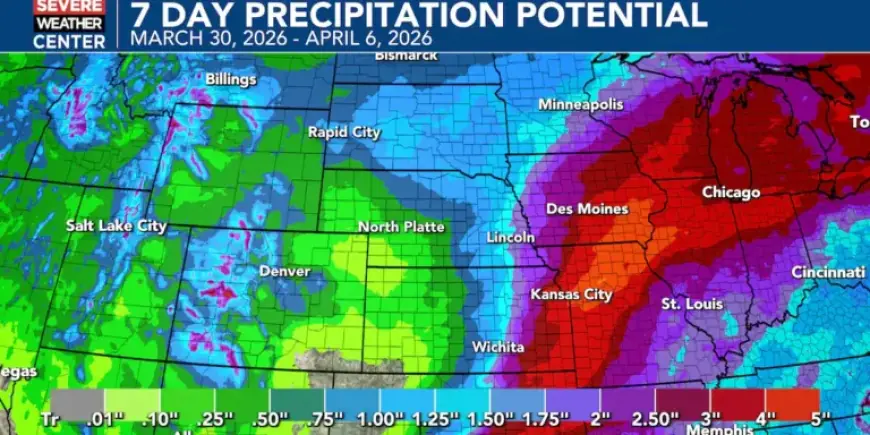
Precipitation Totals and Impacts
Forecast totals vary across Nebraska. Eastern areas may receive about 0.50 to 1.50 inches of rain.
Western sections are likely to see around 0.25 to 0.75 inches. That moisture should help green-up vegetation and ease drought and fire concerns.
Sunday — Easter Outlook
Good news for Easter Sunday: dry, mostly sunny conditions are expected. Highs should reach the mid-50s to mid-60s.
What Residents Should Do
- Tuesday: Secure outdoor items before strong winds arrive.
- Wednesday & Friday: Carry an umbrella and plan indoor activities when possible.
- Thursday: Use the brief break to complete outdoor chores.
- Sunday: Enjoy the nicer conditions for Easter plans.
Forecasters note cooler, wetter conditions as weather returns this week. Filmogaz.com will provide updates if timing or intensity changes.