


NASA Map Reveals Meteor Fragment Impact Sites in Harris, Montgomery Counties
NASA has published a strewn field map showing where fragments may have fallen after a meteoroid broke apart Saturday. The map points to areas in north Harris County and parts of Montgomery County.
Event overview
Eyewitnesses reported seeing the fireball from as far away as Dallas-Fort Worth, Austin, and Rockport. Multiple weather radars recorded signatures consistent with falling meteorites for about eight minutes after the breakup.
Meteoroid details
The NASA Meteoroid Environment Office estimates the object weighed roughly one ton. It was about three feet across before atmospheric entry. The resulting fireball released energy equal to roughly 26 tons of TNT.
Most of the meteoroid’s mass vaporized or broke into tiny droplets in the atmosphere. Only a small percentage of the original mass likely survived to reach the ground.
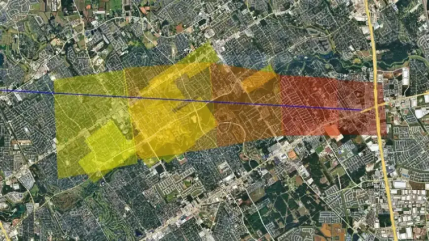
Strewn field map and size zones
The NASA map provides a simplified estimate of where fragments might have landed. It outlines zones corresponding to likely fragment masses.
- Dark red: potential 10 kg fragments.
- Red: potential 1 kg fragments.
- Dark orange: potential 100 g fragments.
- Light orange: potential 10 g fragments.
- Yellow: potential 1 g fragments.
Geographic focus
The mapped corridor crosses north Harris County and parts of Montgomery County. The graphic shows probable fall locations and relative fragment sizes.
Public guidance
NASA urges caution for anyone searching for meteorites. The agency reminds people to respect private property and avoid trespassing.
Filmogaz.com will continue to follow updates from NASA and local authorities about the meteor fragment impact sites. Readers should check official channels before attempting any searches.