


Severe Thunderstorms Forecast Across Plains From Texas to Iowa Over Next 5 Days
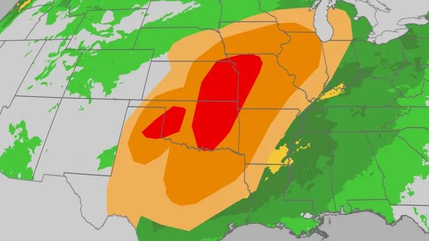
Weather. com forecasts a surge of severe thunderstorms sweeping the Plains, stretching from Texas into Iowa. The threat matters now because forecasts cover the next five days and include the potential for strong tornadoes across a wide swath of the U. S.
Severe Thunderstorms Threaten Plains From Texas to Iowa
Forecasters are warning of a severe weather outbreak centered on the Plains, with a geographic corridor running from Texas to Iowa. The advisory highlights a five-day threat window during which severe thunderstorms could organize and produce strong tornadoes. That combination of duration and reach places numerous communities in the path of repeated storm rounds rather than a single, isolated event.
The most immediate, measurable impacts identified in the forecast are the possibility of strong tornadoes and sustained periods of severe weather over several days. Because the threat is both broad and prolonged, local response systems face a higher likelihood of repeated activations and sustained strain on emergency resources across multiple jurisdictions.
Texas Faces Multiple Days of Severe Storms
Texas is singled out in the five-day outlook as a primary area of concern, with severe storms expected to aim for the state over the next 5 days. That timeline creates an extended window for hazardous conditions to develop, particularly as rounds of severe thunderstorms move northeastward along the Plains corridor.
Weather. com’s forecast frames the situation as an outbreak rather than a single-day event, underscoring how successive storm systems can elevate the cumulative risk. The timing matters because overlapping storm episodes increase the chances that communities will see repeat impacts — from structural damage to interrupted travel and emergency operations — within a compressed span of time.
Local officials and emergency planners along the Texas-to-Iowa corridor will need to monitor conditions closely throughout the five-day period. Resource allocation and public messaging may be adjusted in response to evolving threat levels and any near-term confirmations of severe tornado potential.
Wide Swath of the U. S. Faces Days of Severe Weather
The broader forecast frames this as a wide swath of the U. S. confronting days of severe weather, not isolated pockets. That breadth means states beyond the immediate Plains corridor should remain alert to shifting storm trajectories and timing. The most significant, confirmed elements of the projection are the geographic span—from Texas to Iowa—the multi-day duration, and the explicit possibility of strong tornadoes within that span.
What makes this notable is the combination of scale and persistence: a prolonged five-day window across a large region raises the probability that multiple communities will contend with severe thunderstorms over successive days. That pattern typically complicates both preparedness and recovery efforts because crews and supplies may be committed early in the threat period and harder to reposition if new damage occurs downtrack.
Emergency managers and residents in the Plains should treat the forecast as an extended alert phase and be prepared to respond to severe thunderstorms during the next five days. Staying tuned to local warnings and official guidance will be essential if conditions escalate and tornado confirmations emerge within the threatened corridor.