


Weather: Blizzard warnings expand and snow totals increased for NYC and the Tri-State weather threat
A major winter storm is rapidly intensifying off the coast, prompting expanded blizzard warnings across the Tri-State area as the weather system bears down. The storm has already derailed thousands of flights, put more than 40 million people under blizzard warnings and threatens heavy snow, coastal flooding and power outages while preparations continue.
Blizzard Warning now covers all 29 counties through 6 p. m. Monday
The entire Tri-State area was placed under a Blizzard Warning through 6 p. m. Monday, with all 29 counties in the viewing area covered under the warning. Forecasters described the setup as exceptionally rare — a pattern not seen since the Blizzard of 1996 and with an upper-air pattern resembling the Blizzard of 1978.
Snow, subfreezing temperatures and travel conditions worsening in New York City and metro area
Snow is falling across New York City and the metropolitan area, with accumulations starting to pile up, reduced visibilities and winds ramping up toward blizzard criteria. Temperatures have dropped below freezing faster than expected, locking in cold air overnight and allowing snow to accumulate quickly. Roads that were wet and slushy earlier have become snow-covered, and travel is deteriorating rapidly tonight as the storm evolves into a full-blown blizzard.
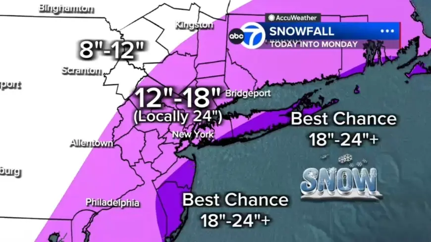
Forecast shows heavy bands, high hourly rates and localized two-foot totals — Weather system set to bring most intense snow from midnight through daybreak
Forecast models indicate the storm will organize and intensify dramatically tonight, with widespread heavy snow by early evening and the most intense snowfall likely from midnight through daybreak Monday. Embedded snow bands could produce 2- to 3-inch-per-hour rates; locations stuck under a band for several hours could quickly rack up totals near two feet or more. Two potential bands appear most likely to develop: one stretching from New Jersey into the Hudson Valley and another from Long Island down to the Jersey Shore.
Projected totals range widely; coastal areas face the highest amounts and prolonged blizzard conditions
Widespread totals of 12 to 18 inches are expected across much of the region, with localized 18–24-plus inches possible in eastern Long Island, the South Shore of Nassau County and parts of the Jersey Shore. Areas farther north and west are expected to see under 12 inches, for example Pike and Sullivan counties. Some coastal communities may endure 12 to 16 consecutive hours of blizzard conditions. Snow is expected to continue through Monday morning, remaining heavy at times, especially from the city eastward, then begin easing midday and tapering to lighter bursts late afternoon and evening while winds remain strong well into Monday.
High winds, coastal flooding and power outages expected
Gusts of 50 to 60 mph are possible, especially along the coast, and the National Weather Service warned the storm could bring wind gusts up to 55 mph, creating whiteout conditions that "will make travel treacherous and potentially life-threatening. " Officials warned that strong winds, combined with the weight of heavy, wet snow, "will likely result in scattered to numerous power outages. " Coastal flooding is a particular concern along the South Shore of Long Island and the Jersey Shore, where 2 to 3 feet of inundation is possible in vulnerable back-bay areas during high tide.
Widespread human and travel impacts: flights, airports and health risks
More than 14, 000 U. S. flights had been disrupted by the storm as of 5: 30 p. m. ET on Sunday; about 8, 858 flights were canceled and another 5, 196 delayed. JetBlue, American Airlines, Delta, Southwest and United announced they would waive change and cancellation fees ahead of the storm at many major Northeastern flight hubs. Maintenance crews cleared snow from a taxiway at LaGuardia Airport on Jan. 26, 2026, and travelers waited for flights at John F. Kennedy International Airport on Nov. 18, 2025, illustrating ongoing airport strain.
More than 40 million Americans are under blizzard warnings, and states of emergency first declared in New York and New Jersey have been expanded to include Connecticut, Delaware, Massachusetts and Rhode Island. The heaviest snow is forecast to begin Sunday night, with potential totals Sunday night into Monday topping 18–24 inches in New York City, Philadelphia and Boston. A Tennessee man died after suffering a heart attack while shoveling snow, adding to the storm toll; experts warned that shoveling snow could pose a dangerous health risk for one group — unclear in the provided context which group that was.
City preparations and official warnings
New York City Emergency Management Commissioner Christina Farrell provided an update on storm preparations and cited three factors that make the event uniquely challenging: the amount of snow, heavy winds and the potential for minor to moderate coastal flooding in coastal areas. Officials reiterated the blizzard criteria — gusts over 35 mph, heavy snow and visibility under a quarter-mile for at least three hours — and noted that many parts of the region, including inland areas such as Sussex, Poughkeepsie and Newburgh, are likely to meet or exceed that threshold tonight into Monday.