


Blizzard Warning: Tri‑State Faces Long‑Duration Blockbuster Storm That Could Mirror 1978 and 1996 Setups
The Blizzard Warning is in effect for the entire Tri‑State through 6 p. m. Monday, and the first people to feel the impact will be coastal communities, transit riders and anyone relying on power or road travel. Snow is already falling across New York City and the metro area; temperatures have dropped below freezing, winds are ramping up, and rapid accumulation is expected as the storm organizes into a long‑duration blockbuster.
Blizzard Warning: who in the Tri‑State faces the sharpest impacts
Here’s the part that matters: coastal towns, the South Shore of Long Island, the Jersey Shore, and densely populated city neighborhoods will see the combination of heavy snow and high wind first. Expect travel to deteriorate quickly — roads that were wet and slushy this afternoon are becoming snow‑covered — and critical services strained where power lines and trees are vulnerable to heavy, wet snow.
Current conditions and the storm’s immediate evolution
Snow is already reducing visibility across New York City and the surrounding metropolitan area, with near‑blizzard criteria reached in places as winds pick up. The storm is organizing and intensifying dramatically tonight, with the most intense snowfall likely from midnight through daybreak Monday. Temperatures dropping below freezing faster than anticipated will help snow accumulate quickly as the event ramps up.
Banding, rates and projected totals
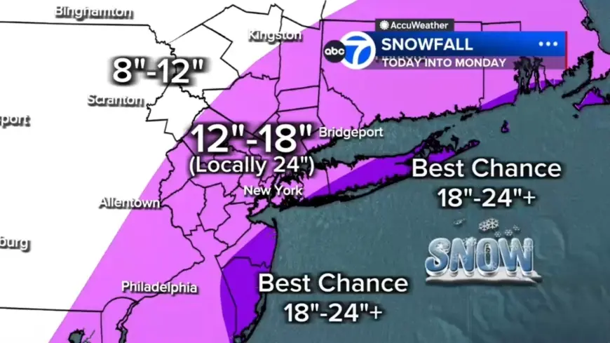
- Embedded snow bands could produce 2–3 inches per hour; sustained placement under a band could put local totals near or over two feet.
- Two potential bands are most likely to develop: one stretching from New Jersey into the Hudson Valley; another from Long Island down to the Jersey Shore.
- Expected spreads: widespread 12–18 inches across much of the region; localized 18–24+ inches in eastern Long Island, the South Shore of Nassau County, and parts of the Jersey Shore; under 12 inches farther north and west (for example, Pike and Sullivan counties) where moisture is less concentrated.
Infrastructure threats: wind, power outages and coastal flooding
Wind gusts of 50 to 60 mph are possible, especially along the coast. That exceeds the blizzard threshold for sustained blizzard conditions and raises the likelihood of power outages as heavy, wet snow weighs down trees and wires. Coastal flooding is an additional concern: the South Shore of Long Island and the Jersey Shore could see 2 to 3 feet of inundation in vulnerable back‑bay areas during high tide.
To qualify as a blizzard, conditions must include gusts over 35 mph, heavy snow, and visibility under a quarter‑mile for at least three hours. Many parts of the region — including inland areas like Sussex, Poughkeepsie, and Newburgh — are likely to meet or exceed that threshold tonight into Monday. Some coastal communities may endure 12 to 16 consecutive hours of blizzard conditions. Winds are expected to remain strong well into Monday even after heavy snow tapers.
Preparedness notes and official briefing
Live updates are ongoing; check back for frequent updates. Recent updates indicate New York City’s emergency management leadership joined coverage to outline preparations, highlighting three challenges that make this storm uniquely difficult: the amount of snow, heavy winds, and potential for minor to moderate coastal flooding in coastal areas. Details may evolve.
It’s easy to overlook, but roads can switch from passable to impassable rapidly when heavy bands set up and temperatures stay below freezing. The real question now is how long those intense bands lock into place and which communities remain under them the longest.
- Live conditions: snow already falling; visibilities reduced.
- Timing: heaviest snowfall expected from midnight through daybreak Monday; snow continues through Monday morning and eases midday into lighter bursts late afternoon and evening.
- Wind threat: gusts 50–60 mph near the coast; blizzard criteria defined as gusts over 35 mph, heavy snow, visibility under a quarter‑mile for 3+ hours.
- Flooding risk: 2–3 feet of inundation possible in vulnerable back‑bay areas during high tide along the South Shore of Long Island and the Jersey Shore.
What’s easy to miss is the historical note: all 29 counties in the local viewing area are covered under the warning — a coverage pattern not seen since the Blizzard of 1996 — and the upper‑air pattern has been compared to the Blizzard of 1978. That comparison frames the scope but does not define exact outcomes for individual communities.
Readiness tip: if you are in an area likely to see heavy bands, avoid travel once visibility drops and prepare for possible power interruptions. The situation will evolve through Monday evening; officials have stressed preparation and caution as the storm progresses.