


Blizzard Warning Sweeps Tri-State and Philadelphia Area as Storm Intensifies
A rapidly intensifying coastal storm has put the region under a widespread blizzard warning, and the blizzard is expected to bring heavy snow, damaging winds and coastal flooding from Sunday night into Monday. The warning covers the entire Tri-State area through 6 p. m. Monday and a broad swath of the mid-Atlantic including Philadelphia, New Jersey and Delaware.
Blizzard criteria and the unusual scale of the warning
The advisory is framed by the technical definition of a blizzard—three or more hours of winds gusting 35 miles per hour or greater, falling or blowing snow, and visibility under a quarter-mile—and officials say many parts of the region are likely to meet or exceed that threshold tonight into Monday. All 29 counties in the Tri-State viewing area are included in the warning, a sweep not seen since the Blizzard of 1996.
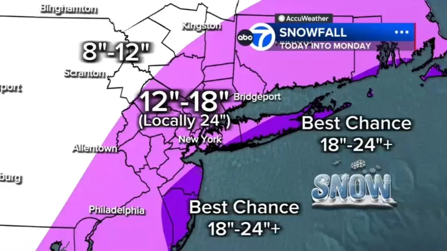
Where the heaviest snow could fall
Forecasts call for widespread 12 to 18 inches across much of the region, with localized totals of 18 to 24-plus inches possible in eastern Long Island, the South Shore of Nassau County and parts of the Jersey Shore. Farther north and west—examples named include Pike and Sullivan counties—will likely see under 12 inches where the storm's moisture is less concentrated.
Bands, rates and timing
Two potential heavy-snow bands are most likely to develop: one stretching from New Jersey into the Hudson Valley and another from Long Island down to the Jersey Shore. Embedded snow bands could produce 2 to 3 inches per hour, and locations trapped under a band for several hours could quickly rack up totals near two feet or more. The most intense snowfall is expected from midnight through daybreak Monday, with widespread heavy snow by early evening and snow continuing through Monday morning, especially from the city eastward.
Wind, coastal flooding and power risks
Overnight through Monday morning, wind gusts of 50 to 60 mph are expected, especially along the coast. The forecast warns of power outages as heavy, wet snow weighs down trees and wires. Coastal flooding is a major concern—particularly along the South Shore of Long Island and the Jersey Shore—where 2 to 3 feet of inundation is possible in vulnerable back-bay areas during high tide, and an AccuWeather Alert has been posted for heavy snow, blizzard conditions, high winds, coastal flooding and beach erosion for Sunday into Monday.
Timing for drivers, transit and local notices
Snow is already falling across New York City as temperatures dropped below freezing faster than expected, and that cold air is expected to lock in overnight so snow will accumulate quickly. Roads that are wet and slushy this afternoon are forecast to become snow-covered by evening, and travel will deteriorate rapidly tonight as the storm evolves into a full-blown blizzard. Drivers are urged to use caution and consider staying off the roads from Sunday evening through Monday morning as snowfall rates pick up.
Light precipitation is expected to begin Sunday morning in some areas, with places northwest of Philadelphia likely to start with light snow showers while ground temperatures above freezing and air temperatures in the mid-30s could allow initial snow to melt on contact. A mix of rain and snow is expected around Philadelphia, with rain for areas to the south and east; the high temperature on Sunday is forecast near 39 degrees before temperatures fall late in the day and all areas change to snow by evening.
Closures, cancellations and what comes next
Local service changes and event shifts are already in place: Bee-Line Bus service is suspended through 2 p. m. Monday, Feb. 23, and Westchester County will monitor road conditions and provide updates as necessary. Broadway's "Operation Mincemeat" has announced a livestream concert Sunday night at 5: 30 p. m. after canceling its final live performance because of the storm.
By Monday morning, snow is expected to begin tapering off west to east as the coastal storm continues to strengthen and move away from the coast. Conditions are forecast to start easing midday, with snow tapering to lighter bursts late Monday afternoon and evening, though winds are expected to remain strong well into Monday.