


Weather: Blizzard Warnings Expanded as Thousands of Flights and Transit Services Halt
A rapidly intensifying coastal storm has prompted a regionwide escalation of alerts and travel stoppages, with the entire Tri-State placed under a Blizzard Warning through 6 p. m. Monday. The developing Weather threat is producing heavy, wet snow, high winds and flight and transit disruptions that are already affecting millions of travelers and residents.
Blizzard Warning covers all 29 counties as storm organizes
Forecasters have expanded the Blizzard Warning to include every county in the Tri-State viewing area — all 29 counties — an arrangement not seen since the Blizzard of 1996. Snow is already falling across New York City, and temperatures dropped below freezing faster than expected, allowing cold air to lock in overnight and enabling rapid accumulation as the storm ramps up.
Roads that were wet and slushy during the afternoon are forecast to become snow-covered by evening, with travel expected to deteriorate rapidly tonight as the system evolves into a full-blown blizzard. The criteria for a blizzard — gusts over 35 mph, heavy snow and visibility under a quarter-mile for at least three hours — are likely to be met in many areas, including inland locations named specifically as Sussex, Poughkeepsie and Newburgh. Some coastal communities may experience 12 to 16 consecutive hours of blizzard conditions.
Flight disruptions surpass 7, 000; airlines waive fees
Air traffic has been severely affected: more than 7, 000 U. S. flights were disrupted as of 6 a. m., with 6, 456 cancellations and an additional 547 delays recorded through Tuesday. Major carriers JetBlue, American Airlines, Delta, Southwest and United announced waivers of change and cancellation fees as hubs across the Northeast prepare for the storm’s expected impact on travel.
Images tied to recent operations show maintenance crews clearing snow from a taxiway at LaGuardia Airport on Jan. 26, 2026, and travelers waiting for flights at John F. Kennedy International Airport on Nov. 18, 2025 — visual reminders of the persistent disruption winter storms can cause at major New York-area airports.
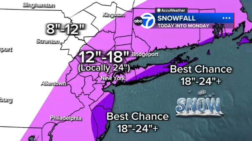
Snow totals, bands from New Jersey into Long Island and Hudson Valley
Forecasters expect widespread snowfall of 12 to 18 inches across much of the region, with localized amounts of 18 to 24-plus inches focused in eastern Long Island, the South Shore of Nassau County and parts of the Jersey Shore. Farther north and west — for example, Pike and Sullivan counties — totals are expected to be under 12 inches where the storm’s moisture will be less concentrated.
The storm is likely to produce embedded snow bands capable of 2 to 3 inch-per-hour rates. Two particular band corridors are highlighted: one stretching from New Jersey into the Hudson Valley, and another from Long Island down the Jersey Shore. Any location stuck under one of these bands for several hours could quickly rack up totals near two feet or more. What makes this notable is the combination of rapid intensification offshore and the locked-in cold air, which together create conditions for both very high snowfall rates and extended duration in coastal bands.
Coastal flooding, power outages and health risks
Strong winds and heavy, wet snow raise the prospect of scattered to numerous power outages as trees and wires come under stress. Forecasts call for wind gusts of 50 to 60 mph, especially along the coast, and the National Weather Service has warned gusts could reach up to 55 mph, creating whiteout conditions that will make travel treacherous and potentially life-threatening.
Coastal flooding is also a major concern: the South Shore of Long Island and the Jersey Shore could see 2 to 3 feet of inundation in vulnerable back-bay areas during high tide. Public health risks include hazardous exertion from shoveling; one Tennessee man has died after suffering a heart attack while shoveling snow, underscoring the dangerous health consequences that can accompany heavy winter storms.
Local actions: Bee-Line suspension, Westchester monitoring, and a livestreamed Broadway concert
Local authorities and services have begun implementing operational changes. Bee-Line Bus service is suspended through 2 p. m. Monday, Feb. 23, and Westchester County will monitor road conditions and provide updates as necessary. Broadway’s production Operation Mincemeat has canceled its final live performance and will present a livestream concert Sunday night at 5: 30 p. m.
Snow is expected to continue through Monday morning, remaining heavy at times, especially from the city eastward. Conditions should begin easing midday Monday with snow tapering to lighter bursts by late afternoon and evening, though winds are likely to remain strong well into Monday.