


Weather alert: Major East Coast storm to slam Tri-State, thousands of flights canceled
A dangerous, potentially historic winter storm will slam the Tri-State area later today, and weather forecasters warn it could produce blizzard conditions, heavy snow, damaging winds and coastal flooding that will disrupt travel and utilities.
Weather timeline and warnings
The event begins this morning with scattered light snow and rain across the region, then will rapidly intensify through the afternoon and peak overnight. Light snow is falling across Sullivan, Ulster, Dutchess and Orange counties and parts of northwest New Jersey, while most of New Jersey is seeing rain early and some sleet mixed in around Ocean County before transitioning to rain. Roads are mainly wet at the start of the day, which may delay initial snow accumulation.
Visibility is already reduced in spots, with White Plains down to 0. 2 miles, and every county in the region is under a Blizzard Warning. Forecasters say the strengthening coastal storm will pull up the East Coast and tap into enough cold air to flip rain to snow across New York City and New Jersey by midday, with snow becoming more widespread and intense after lunchtime.
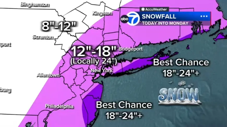
Where snow will pile up
With hours of heavy snow overnight, totals are expected to rise quickly: 12 to 18 inches across most of the region, localized 18 to 24 inches in a central corridor from the Jersey Shore to Long Island, and the best chance for 24-plus inches on the East End of Long Island and parts of the Jersey Shore. Areas north and west such as Pike, Sullivan and Ulster counties could see up to 12 inches. A nor'easter is forecast to bring snow totals of over a foot to parts of the Northeast beginning Sunday, and the heaviest snow will begin to fall Sunday night, with potential 18–24 inch totals Sunday night into Monday in New York City, Philadelphia and Boston.
Wind, whiteouts and coastal flooding
By evening, heavier bands are expected to form and conditions will deteriorate rapidly with snowfall rates of 1 to 2 inches per hour and whiteout visibility. One forecast noted wind gusts of 50 to 60 mph near the coast; the National Weather Service warned gusts could reach up to 55 mph, creating whiteout conditions that will make travel treacherous and potentially life-threatening. Winds whipping off the ocean could push water inland, with up to 3 feet of coastal inundation possible around high-tide cycles tonight into Monday morning, especially along Long Island and the Jersey Shore.
Forecasters also warned that strong winds combined with the weight of heavy, wet snow will likely result in scattered to numerous power outages due to downed trees and lines.
Flights and surface transportation hit hard
Thousands of U. S. flights have been canceled as the Northeast prepares for the blizzard. The total number of disrupted flights reached more than 7, 000 as of 6 a. m., with 6, 456 U. S. flights canceled and an additional 547 U. S. flights delayed so far through Tuesday. Jetblue, American Airlines, Delta, Southwest and United announced they will waive change and cancellation fees ahead of the storm.
On the ground, New Jersey will temporarily lower all posted speed limits to 35 miles per hour on Interstate and State highways starting at 3 p. m. Sunday. Travel is expected to grow increasingly difficult as heavier snow organizes later today and into the overnight period.
Local impacts, safety and what comes next
Officials note this is a rare event: the storm is described as poised to be the biggest snow-maker to hit the Tri-State area since the January 2016 storm, the largest on record for New York City, and the last time a blizzard warning was issued in the region was March 2017. Meteorologists say the system involves the convergence of energy from the Ohio Valley colliding with Gulf and ocean moisture to produce a storm that almost resembles a winter hurricane.
There are already serious health and safety consequences: a Tennessee man died after suffering a heart attack while shoveling snow. Tonight is expected to be the worst period, with widespread heavy snow and 1 to 2 inches per hour rates, and heavy snow is forecast to continue through early Monday morning before improving by mid-morning. Snow is expected to taper in the second half of Monday, though winds will remain strong and travel impacted. Flight disruptions noted through Tuesday will affect travelers for several days as carriers adjust schedules.
The confirmed next milestones: the heaviest snow is expected to begin Sunday night, New Jersey’s speed-limit change takes effect at 3 p. m. Sunday, and forecasters say conditions should start improving by mid-morning Monday as snow tapers later that day.