


Massachusetts State Of Emergency: Practical plans for parents and commuters before the nor’easter drops up to two feet of snow
For parents juggling school closures and commuters facing dangerous travel, the coming nor’easter changes the immediate routine: expect heavy snow, powerful gusts, coastal flooding risk and likely outages. If you’ve been watching talk of a massachusetts state of emergency, the near-term decisions — whether to keep kids home, delay travel or prepare for power interruptions — are the first effects felt by households and local districts.
Massachusetts State Of Emergency and who should act first
Here’s the part that matters: families with school-age children and anyone who regularly commutes into or through coastal and metro corridors are the groups most exposed during the storm window. Several school systems have already listed closures for Monday, and at least one district has extended closures into Tuesday. Parents should confirm district messages before making plans, and commuters should assume conditions will be hazardous where heavy snow and strong winds intersect.
What’s easy to miss is the combination of heavy snowfall rates and high winds — that’s what drives whiteout conditions and rapid travel failure rather than just deep snow on the ground.
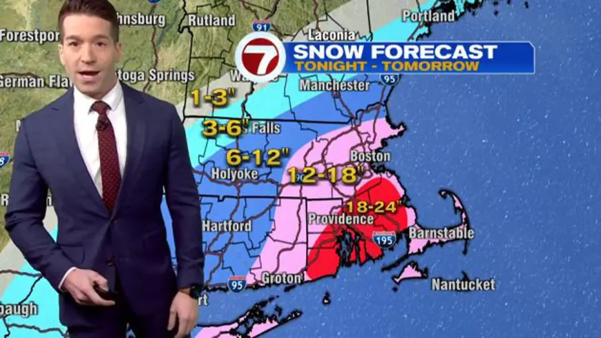
- Snow totals being cited include as much as 18–24 inches on parts of the South Shore and South Coast.
- Boston, MetroWest out to Route 495 and Cape Cod are in a 12–18 inch range in current estimates.
- Worcester County and parts of western areas are expected to see 6–12 inches in the more detailed forecast runs.
- Travel could be dangerous with potential whiteout conditions where gusts are strongest; coastal flooding and power outages are listed among likely impacts.
Storm timing, warnings and practical details
A Blizzard Warning has been issued for portions of eastern, northeastern and southeastern Massachusetts, including the city of Boston, with the warning window and storm timing that will shape local actions. Current guidance sets the warning period for parts of the region from the late afternoon before the storm through the overnight period into the following morning, and the storm itself is expected to move in Sunday night and continue through Monday evening. The heaviest snow is expected early Monday morning, when snowfall rates could exceed two inches per hour and produce blizzard conditions.
Micro timeline (key forecast points):
- Blizzard Warning window covers the late-afternoon start through the following morning for affected coastal and metro areas.
- Accumulating snow is expected to begin Sunday night, with the hardest snow early Monday morning.
- Storm impacts are expected to continue into Monday evening with tapering conditions thereafter.
Schools and districts listed as closed for Monday in recent notices include a mix of individual schools and regional districts; one large district has announced closures for Monday and Tuesday. Parents should rely on direct district communications for the most current status.
Practical steps households and local leaders should consider now: charge devices, gather essential supplies, prepare for possible power outages, avoid nonessential travel during the heaviest periods, and monitor district communications about closures. The real question now is whether temporary sheltering or road restrictions will be needed in the hardest-hit coastal and southern areas if conditions deteriorate beyond current warnings.
Short checklist of forward signals that would confirm severity: extension of warning windows into later periods, reports of sustained whiteout conditions, and confirmation of coastal flooding in low-lying areas. These are the local changes that typically move communities from planning to active response.
The bigger signal here is how quickly snow rates combine with wind; high rates of accumulation plus gusty wind produce the most disruptive outcomes for travel and power infrastructure.