


Ri State Of Emergency: Blizzard Warning Issued as Nor'easter Threatens Historic Snow
Ri State Of Emergency appears in public discussion as Rhode Island prepares for a powerful nor'easter that has prompted a blizzard warning for the entire state. The warning matters because forecasters predict heavy, wet snowfall combined with strong northeast winds that will produce near-zero visibility, likely power outages and virtually impossible travel across the state.
Ri State Of Emergency: Development details
Forecasters have issued a blizzard warning covering all of Rhode Island and eastern Massachusetts from Sunday evening through Tuesday morning. The nor'easter's leading edge is expected to push into Southern New England between 7 p. m. and 10 p. m. Sunday, with snowfall rates intensifying around midnight and into Monday morning at 1–2+ inches per hour.
Winds are forecast to play a major role. Models and forecasts indicate northeast wind gusts commonly in the 40–60 mph range and gusts up to 65 mph at times, with a period of sustained strong gusts from midnight until about noon on Monday. The National Weather Service has also issued related storm warnings and a coastal flood warning for nearby Cape Cod and the Islands.
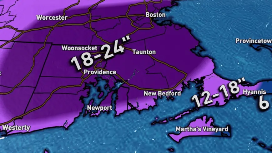
Snowfall amounts have been revised upward: a widespread 18 to 24 inches is now expected across most of Rhode Island and southeastern Massachusetts, with 12 to 18 inches along the immediate south coast and toward the Cape Cod Canal. The National Weather Service has issued town-specific predictions including Providence (21 inches, with a high-end estimate of 35 inches), Block Island (17 inches, high-end 31 inches), Newport (14 inches, high-end 34 inches) and Westerly (19 inches, high-end 29 inches).
Context and escalation
Forecasters characterize the storm as potentially historic and destructive where wet snow combines with strong northeast winds. The track of the nor'easter is near the so-called "benchmark" path, a setup that has pushed snowfall forecasts higher. What makes this notable is that higher surface temperatures are increasing the water content of the snow, producing a heavier wet snow that places more stress on trees and power infrastructure.
Snow is expected to fall most intensely Sunday night into Monday morning, with near-whiteout conditions persisting through the morning commute. The worst of the snowfall may not ease until about 3 p. m. Monday, though light to moderate snow could linger into the evening hours.
Immediate impact
Travel is expected to become nearly impossible during the height of the storm. Blizzard conditions—defined by heavy snow and/or blowing snow that reduces visibility to a quarter-mile or less for three hours or longer combined with sustained winds or frequent gusts of 35 mph or greater—are likely for several hours across the state.
The combination of wet, heavy snow and powerful winds will increase the likelihood of downed tree limbs and wires, making scattered to numerous power outages likely, particularly along the south coast. The National Weather Service warns that roads could become impassable; officials advise restricting travel to emergencies only and carrying winter survival equipment if travel is unavoidable. If stranded, travelers are urged to remain with their vehicle.
Forward outlook
Key milestones in the storm timeline are clear: the initial band of snow arrives Sunday evening, snowfall rates peak around midnight into Monday, and the most intense wind gusts are expected from midnight through midday Monday. By 7 a. m. Monday, areas could already see close to a foot on the ground; the heaviest accumulation is expected through Monday afternoon, with lingering lighter snow into the evening.
Authorities and weather services will continue to update warnings and forecasts as the storm evolves. Preparations—clearing supplies, securing outdoor objects, and preparing for extended outages—should be completed before the snow begins Sunday night. The broader implication is that the combination of a near‑benchmark storm track and wet, heavy snow raises the risk profile for both infrastructure damage and prolonged disruptions across Rhode Island.