


Snowfall Weather Forecast as Yellow Warnings Hit Wales, Northern Ireland and Southern England
The Snowfall Weather Forecast for the UK shows yellow warnings for rain, snow and ice in place across wide swathes of the country, raising the risk of travel disruption, flooding and power cuts during a cold snap that followed a drop in temperatures this week.
Snowfall Weather Forecast: warnings and where they apply
Forecasters have issued yellow warnings for rain and snow that came into force early on Wednesday across Northern Ireland, with a separate yellow warning for rain covering southern parts of England. Another yellow warning for snow is due to begin later for parts of Wales, the Midlands and the southern Pennines, and an ice warning for Wales is set to kick in during the evening. Yellow National Severe Weather Warnings remain in force until Thursday morning.
Northern Ireland and southern England facing heavy rain and hill snow
Frontal systems will bring a mixture of rain, sleet and hill snow to Northern Ireland and rain to southern and central Britain today and overnight, with strong winds through Thursday. In southern England, a yellow warning covers periods of heavy rain through Wednesday and into Thursday; many areas are expected to see 10-20 mm, 20-30 mm is possible along the south coast, and up to 50 mm across Dartmoor. In the wettest locations, 30-50 mm (1. 2-2. 0 in) of rain could fall, posing a threat to areas already affected by flooding earlier in 2026.
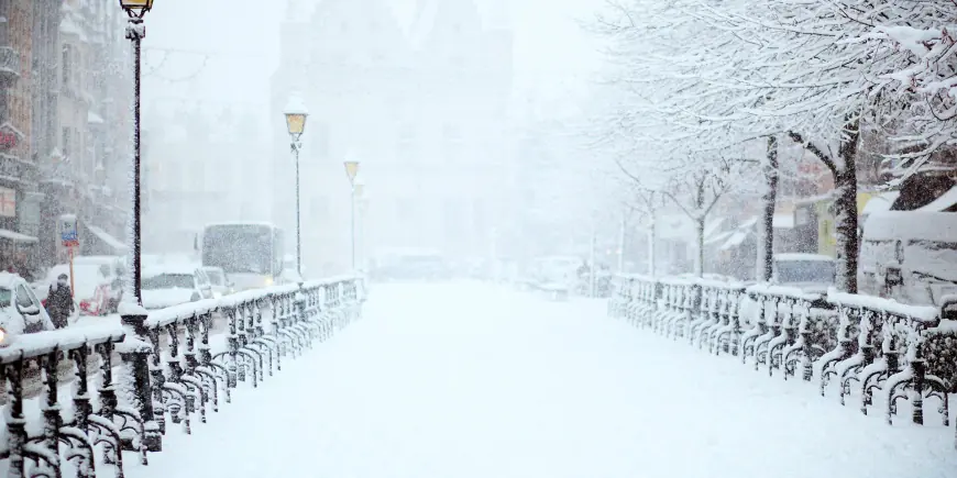
Wales warned: 18 counties under yellow alerts and travel risks
Large parts of Wales face yellow warnings for snow and ice, with a yellow snow warning affecting 18 counties and snow expected until 06: 00 GMT (1 a. m. ET) on Thursday. A yellow warning for ice in the same area is in effect until 10: 00 GMT (5 a. m. ET) on Thursday. People living on higher ground in mid and southeast Wales could see up to 20 cm (8 in) of snow. The counties named in the warning are Blaenau Gwent, Bridgend, Caerphilly, Carmarthenshire, Ceredigion, Conwy, Denbighshire, Gwynedd, Merthyr Tydfil, Monmouthshire, Neath Port Talbot, Newport, Pembrokeshire, Powys, Rhondda Cynon Taf, Swansea, Torfaen and Wrexham.
Snow levels, winds and the cold snap
Temperatures fell this week after north-westerly winds, with parts of north-east Scotland dropping below -9C (16F) on Tuesday night and many northern and central areas seeing a frosty start to Wednesday. The UK Health Security Agency has issued a cold weather alert covering most of England until 18: 00 GMT (1 p. m. ET) on Friday. Wind gusts of 45-55 mph were warned as an extra hazard, and forecasters said strong east to northeasterly winds could increase impacts and create large waves on east-facing coasts along the English Channel.
What to expect on hills, roads and rail
As rain shifts north into Wales, the west Midlands and northern England during the late afternoon and evening, some of it will turn to snow, especially over the hills. Several centimetres are expected to accumulate above about 150-200 m, with the possibility of up to 15 cm over the highest ground of mid and south-east Wales, Herefordshire, Shropshire and the southern Pennines. The Met Office forecaster Jason Kelly said snowfall of 2-5 cm is likely above 150-200 metres, with 10-15 cm possible above 250-300 metres across mid and southeast Wales, Herefordshire, Shropshire and the southern Pennines, and small amounts generally less than 2 cm at lower levels. At low levels a mix of rain and sleet is more likely, with some wet snow at times; that wet and wintry mix could make travelling difficult during Wednesday evening and overnight and may bring possible power cuts.
Northern Ireland will see persistent rain at low levels and snow over high ground, especially the Sperrins, where several centimetres could accumulate above 250 metres. Any lying snow there is expected to thaw during the evening and overnight. Some snow could also start to affect the Peak District, Pennines and possibly south-west Scotland during the night.
Local disruptions and odd footage
Forecasters have warned of travel disruption, a small chance of delays on roads from stranded vehicles and impacts on train and flight schedules. They warned of a slight chance that some rural communities could become cut off and a small chance of cuts to power and mobile services with strong winds forecast. Footage linked to the coverage shows Sam Dudley, who was listening to music, appearing shocked at the sight of a train. Trains now stop at Northumberland Park after running through the station for more than a year. The airline warned of major disruption after fog left its aircraft "in the wrong place. " An airport statement described a change as a "faster, more convenient option" in line with other UK airport charges. Separately, part of the line between Ashford and Borough Green had to close in 2021 after a landslip.
Forecasters note there remains some uncertainty in the detailed evolution of the system and urge people to keep up to date with hour-by-hour information on the Weather website and app. As the system clears on Thursday, most areas should turn drier, though Northern Ireland and western Scotland will see cloud and rain increasing by the afternoon and further ice warnings overnight remain possible. The outlook into the weekend stays unsettled with further bands of rain and increasingly mild temperatures as Atlantic air moves in.
Officials say to watch for updates and local warnings; the next confirmed scheduling milestone is the end of the yellow National Severe Weather Warnings on Thursday morning and the end of the cold weather alert at 18: 00 GMT (1 p. m. ET) on Friday.