


Weather threats deepen as blizzard warnings expand across Tri-State and Northeast
A dangerous winter weather event is closing in on the Tri-State area and much of the Northeast, threatening blizzard conditions, heavy snow, damaging winds and coastal flooding as the storm rapidly intensifies through the afternoon and peaks overnight.
Snow and rain already moving in across counties
Light snow and rain began the day across parts of New York and New Jersey, with light snow falling across Sullivan, Ulster, Dutchess and Orange counties and parts of northwest New Jersey. Most of New Jersey was seeing rain early, and some sleet mixed in around Ocean County before transitioning to rain. Roads were wet this morning, which may delay initial snow accumulation, and visibility was already reduced in spots with White Plains down to 0. 2 miles.
Forecast totals, winds and coastal flooding
The strengthening coastal storm will pull up the East Coast and tap into just enough cold air to flip rain to snow across New York City and New Jersey by midday, with snow becoming more widespread and significantly more intense after lunchtime. Heavier bands are expected by evening, and forecasts call for snowfall rates of 1 to 2 inches per hour and whiteout visibility during the worst period.
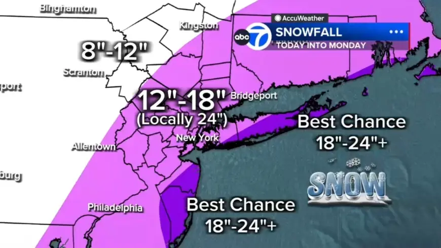
Forecasts list 12 to 18 inches across most of the region, with a localized 18 to 24 inches in a central corridor from the Jersey Shore to Long Island. The best chance for 24-plus inches is the East End of Long Island and parts of the Jersey Shore; totals up to 12 inches are expected north and west in Pike, Sullivan and Ulster counties. Winds whipping off the ocean could push water inland, with up to 3 feet of coastal inundation possible around high-tide cycles tonight into Monday morning, especially along Long Island and the Jersey Shore.
One forecast gave wind gusts of 50 to 60 mph near the coast, while the National Weather Service warned gusts could reach up to 55 mph; forecasters also warned that strong winds combined with heavy, wet snow will likely result in scattered to numerous power outages.
Weather impact on flights and transit
Travel disruptions are already large: more than 7, 000 U. S. flights were disrupted as of 6 a. m. ET, with 6, 456 U. S. flights canceled and an additional 547 U. S. flights delayed through Tuesday. JetBlue, American Airlines, Delta, Southwest and United have announced they will waive change and cancellation fees ahead of the storm.
Public transit is affected: the LIRR will temporarily suspend all service starting at 1: 00 a. m. ET until weather conditions allow for safe resumption.
Warnings, timing and human toll
Every county in the region is under a Blizzard Warning. The storm has been described as the convergence of energy from the Ohio Valley colliding with Gulf and ocean moisture, producing a system that almost resembles a winter hurricane. Forecasters note this could be the biggest snow-maker to slam the Tri-State area since the storm of January 2016, which was the biggest snowstorm to ever hit New York City on record; the last blizzard warning in the region came in March 2017.
Officials say the heaviest snow will begin Sunday night and continue into Monday morning, with conditions improving by mid-morning Monday and snow tapering in the second half of the day, though winds will remain strong and travel impacted. A separate storm toll note says a Tennessee man died after suffering a heart attack while shoveling snow.
What to expect tonight and next steps
Expect the worst conditions tonight: widespread heavy snow, 1 to 2 inches per hour snowfall, near-zero visibility in whiteout conditions and a significant power-outage risk from downed trees and lines. Practical next steps on the schedule include the LIRR suspension at 1: 00 a. m. ET and the onset of the heaviest snow Sunday night; officials have warned that travel will grow increasingly difficult as conditions deteriorate.
Maintenance crews cleared snow from the taxiway at LaGuardia Airport on Jan. 26, 2026, and travelers were photographed waiting for flights at John F. Kennedy International Airport on Nov. 18, 2025. The nor'easter is forecast to bring snow totals of over a foot to parts of the Northeast beginning Sunday, and the heaviest snow Sunday night into Monday could top 18–24 inches in New York City, Philadelphia and Boston.
- Morning: light mix, mainly wet roads; visibility issues in spots
- Afternoon: rain changes to snow for NYC/NJ; snow intensity increases after lunchtime
- Tonight (worst): widespread heavy snow; 1–2 in/hr; strong coastal winds; blizzard conditions
- Monday morning: heavy snow continues early, improving by mid-morning; snow tapers in the second half of the day
Officials say the immediate next milestones are the LIRR service suspension beginning at 1: 00 a. m. ET and the arrival of the heaviest snow Sunday night into Monday morning; flights and road travel are expected to remain heavily disrupted through Tuesday as crews respond to outages and cleanup.