


Blizzard warnings expand across Tri-State as Gov. Sherrill declares New Jersey state of emergency
Blizzard conditions are expected to develop across the Tri-State area Sunday into Monday as a strengthening coastal storm brings heavy snow, damaging winds and coastal flooding; Gov. Sherrill has declared a state of emergency for New Jersey and the state will temporarily lower posted speed limits on Interstate and State highways.
Blizzard warnings cover every county in the region
Every county in the region is under a Blizzard Warning as the storm, which begins with scattered light snow and rain, rapidly intensifies through the afternoon and peaks overnight. A blizzard is defined as three or more hours of winds gusting to 35 miles an hour or greater, falling or blowing snow, and visibility less than a 1/4 of a mile; there are no requirements for the amount of snow when it comes to a blizzard.
Where snow and rain are falling now and how the changeover happens
Light snow is falling across Sullivan, Ulster, Dutchess and Orange counties and parts of northwest New Jersey, while most of New Jersey is seeing rain early. Some sleet mixed in around Ocean County before transitioning to rain. Roads are wet this morning, which may delay initial snow accumulation, and visibility is already reduced in spots — White Plains is down to 0. 2 miles. The strengthening coastal storm will pull up the East Coast and tap into enough cold air to flip rain to snow across New York City and New Jersey by midday; after lunchtime snow becomes more widespread and significantly more intense.
Forecast highlights: heavy bands, coastal inundation and power risks
By evening, heavier bands are expected to develop and conditions will deteriorate rapidly with snowfall rates of 1 to 2 inches per hour and wind gusts of 50 to 60 mph near the coast. Whiteout visibility and widespread power outage potential from downed trees and lines are possible. Winds whipping off the ocean could push water inland, producing up to 3 feet of coastal inundation around high-tide cycles tonight into Monday morning, especially along Long Island and the Jersey Shore.
Timing, totals and local impacts
This morning: a light mix with mainly wet roads and visibility issues in spots. Afternoon: rain changes to snow for New York City and New Jersey, with intensity increasing after lunchtime. Tonight (worst conditions): widespread heavy snow, 1 to 2 inch per hour snowfall, 50 to 60 mph gusts at the coast, near-zero visibility and a power outage risk. Monday morning: heavy snow continues through early morning with improving conditions by mid-morning; snow tapers in the second half of the day but winds remain strong and travel will remain impacted.
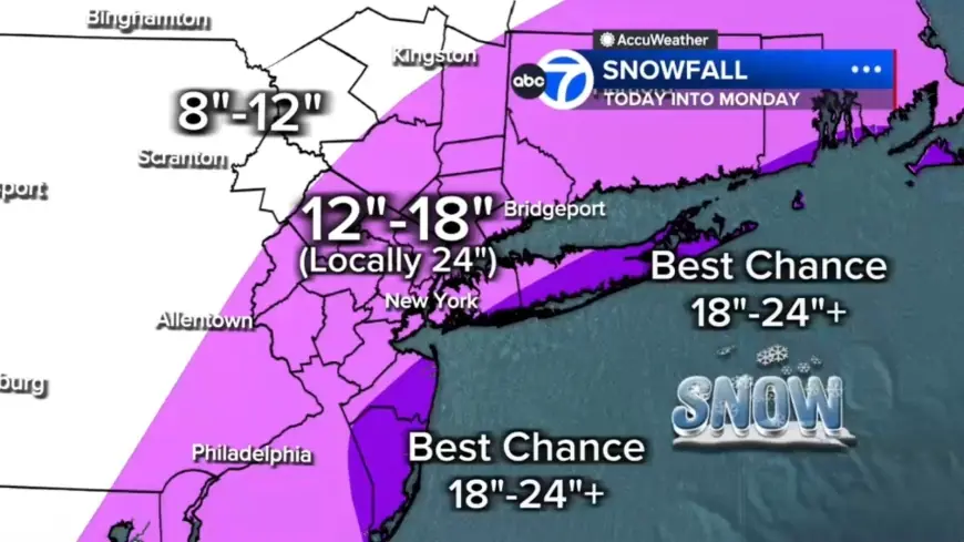
Forecast totals call for 12 to 18 inches across most of the region, with localized 18 to 24 inches in a central corridor from the Jersey Shore to Long Island. The best chances for 24-plus inches are on the East End of Long Island and parts of the Jersey Shore. Areas farther north and west, including Pike, Sullivan and Ulster counties, can expect up to 12 inches.
Philadelphia, South Jersey and driver guidance
A Blizzard Warning will go into effect Sunday for most of the viewing area and now includes Philadelphia; the heaviest snow is set to fall Sunday night and will last into Monday. The day will be cloudy and cooler with rain and snow showers developing and a high near 39. With ground temperatures above freezing and temperatures in the mid 30s, snow will likely initially melt on contact before changing over to snow later in the evening. A mix of rain and snow is expected around Philadelphia early, with rain for areas south and east. Drivers are urged to use caution and consider staying off the roads from Sunday evening through Monday morning as snowfall rates pick up.
State actions and alerts
Gov. Sherrill has declared a state of emergency for New Jersey ahead of the winter storm. New Jersey will temporarily lower all posted speed limits to 35 miles per hour on Interstate and State highways starting at 3 p. m. Sunday. An AccuWeather Alert is posted for Sunday into Monday for heavy snow, blizzard conditions, high winds, coastal flooding and beach erosion.
The storm is expected to bring between 12 and 18 inches of snow to coastal areas and parts of interior South Jersey and Delaware. By Monday morning, snow will begin tapering off west to east as the coastal storm continues to strengthen and move away from the coast.