


Snowfall Weather Forecast: Warnings Across UK as Cold Snap Brings Snow, Heavy Rain and Strong Winds
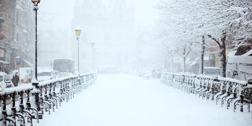
Multiple yellow warnings are in force for rain, snow and ice across parts of the UK as a cold snap produces widespread frost and wintry conditions. The snowfall weather forecast is accompanied by alerts for flooding, travel disruption and possible power and mobile-service cuts.
Met Office Snowfall Weather Forecast and National Alerts
The Met Office has placed areas of the UK under Yellow National Severe Weather Warnings that remain in force until Thursday morning, with separate yellow warnings for rain covering southern England and for rain and snow in Northern Ireland that came into force early on Wednesday. Frontal systems are expected to bring rain and snow to Northern Ireland and to southern and central Britain through Wednesday and overnight, with strong winds through Thursday.
Northern Ireland: Sperrins, hill snow and heavy rain
Northern Ireland will see a mixture of wet and wintry weather throughout Wednesday, with persistent rain at low levels and snow over high ground, especially the Sperrins. Several centimetres of snow could accumulate above around 250 metres, while lower levels are likely to see little or no lying snow. Strong southeasterly winds will accompany the precipitation, and any lying snow should thaw during the evening and overnight.
Wales: 18 counties under yellow snow and ice warnings
A yellow warning affecting 18 counties in Wales warns of snow until 06: 00 GMT on Thursday and an ice warning in the same area remains in effect until 10: 00 on Thursday. The counties listed under the warning are Blaenau Gwent, Bridgend, Caerphilly, Carmarthenshire, Ceredigion, Conwy, Denbighshire, Gwynedd, Merthyr Tydfil, Monmouthshire, Neath Port Talbot, Newport, Pembrokeshire, Powys, Rhondda Cynon Taf, Swansea, Torfaen and Wrexham. People living on higher ground in mid and southeast Wales could see accumulations of up to 20cm in some places, and there is a risk that some rural communities could become cut off.
Southern England and Dartmoor: heavy rain totals and coastal impacts
Southern England faces periods of heavy rain through Wednesday into Thursday. Many areas are expected to see 10-20 mm, with 20-30 mm possible along the south coast and up to 50 mm across Dartmoor. Strong east to northeasterly winds will accompany the rain and large waves may affect some east-facing coasts, particularly along the English Channel. In the wettest locations, 30-50 mm of rain could fall, a volume likely to worsen flooding issues that have affected parts of the country earlier this year.
Snow accumulations, elevations and Jason Kelly's guidance
Chief Forecaster Jason Kelly set out elevation-linked snowfall expectations: 2-5 cm is likely above 150-200 metres, with 10-15 cm possible above 250-300 metres across mid and southeast Wales, Herefordshire, Shropshire and the southern Pennines. Small amounts, generally less than 2 cm, may fall at lower levels. Several centimetres are expected to accumulate over high ground above roughly 150-200m, and some areas of the Peak District, Pennines and possibly south-west Scotland could see snow during the night.
Transport risks: roads, rail, airports, power and communications
The outlook includes clear travel risks. Forecasters warn of a small chance of delays on roads from stranded vehicles and disruption to train and flight schedules, with a slight chance that some rural communities could be cut off. Wind gusts of 45-55 mph form an additional hazard and carry a small chance of cutting power and mobile services. The cold snap has already driven temperatures down: on Tuesday night parts of north-east Scotland fell below -9C (16F) and many northern and central areas began Wednesday with a frost. The UK Health Security Agency has issued a cold weather alert covering most of England until 18: 00 GMT on Friday.
Rail and airport operators have flagged potential disruption. An airport has described a change as a "faster, more convenient option" in line with other UK airport charges, and an airline has warned of major disruption after fog left some aircraft "in the wrong place. " Past infrastructure vulnerability is noted: part of the line between Ashford and Borough Green closed in 2021 after a landslip, and Network Rail has provided an explanation for an occurrence that observers said looked like "something from the X-Files. " That closure was part of engineering works taking place on the line over the school half-term break.
As the rain shifts northwards into Wales, the west Midlands and northern England in the late afternoon and evening, some low-level rain will turn to sleet or wet snow at times, potentially complicating travel on Wednesday evening and overnight and increasing the risk of local power cuts. Strong winds, falling temperatures and overnight freezing mean ice warnings may be needed again in places.
As the system clears on Thursday most areas are expected to turn drier; Northern Ireland and western Scotland will see cloud and rain increasing by the afternoon. The outlook into the weekend remains unsettled, with further bands of rain and some brighter intervals. Temperatures are forecast to become increasingly mild for the time of year as Atlantic air moves in, with the potential for highs of up to 16°C in sheltered places before values return closer to average next week.
There is forecast uncertainty, so it will be worth keeping up to date with hour-by-hour details on the Weather website and app, and with the latest guidance available on the Met Office website, on YouTube, by following updates on X and Facebook, and through mobile apps available for iPhone on the App store and for Android on the Google Play store.
What makes this notable is the combination of heavy rain, coastal waves and hill snow over a compact timeframe—conditions that can rapidly compound to produce local flooding, stranded vehicles and temporary loss of services.