


Fire Weather Watch: Central West Florida fire weather watch, red flag warnings and drought concerns
A Fire Weather Watch is in effect for parts of Central West Florida as officials warn of elevated fire risk amid expanding extreme drought and gusty winds. The fire weather watch follows a red flag warning issued late Saturday for a set window on Sunday, and forecasts show much cooler conditions and even a potential widespread frost or freeze later this week.
Red flag warning details
At 12: 23 p. m. ET on Saturday, the National Weather Service issued a red flag warning valid for Sunday between 1 p. m. and 7 p. m. The warning covers Coastal Levy and Inland Levy as well as Citrus, Hernando and Sumter counties. Residents in those counties can expect winds from the northwest at 10 to 15 mph with gusts up to 25 mph and relative humidity as low as 28 percent.
Fire Weather Watch and precautions
A FIRE WEATHER WATCH is also in effect for Monday for portions of the region. Both the red flag warning for Sunday and the fire weather watch for Monday indicate an elevated fire weather threat caused by dry ground and gusty winds; people are urged to exercise extreme caution outdoors and take note of any burn ban in place. During these elevated conditions, be prepared to take immediate action if a fire starts.
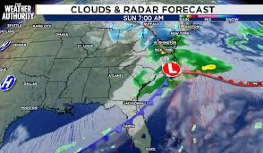
Local forecast and timing
In the Jacksonville, Fla., area the remainder of the day is expected to be partly to mostly cloudy with highs in the low to mid 80s. Cloud cover will increase tonight and it will be mild for this time of year, with low temperatures in the 50s and 60s. A front will bring a few showers overnight tonight through Sunday morning, though activity is not expected to be widespread and rainfall should be generally under a tenth of an inch.
Cooler air, frost and freeze risk
Behind the front temperatures will be much cooler and breezy on Sunday and into early next week, with highs Sunday in the 60s and a mostly cloudy sky. Lows Sunday night are forecast to return to the 30s and 40s. Monday will be the coolest day of the week, with morning temperatures near 40 degrees and highs only in the low to mid 50s as a northerly flow brings cooler air into the area. Another big story later in the week is a likely widespread frost or freeze Tuesday morning, with lows in the 20s and 30s and wind making it feel like the 20s for most of the area.
Outlook and drought status
The rest of the upcoming week looks fairly dry because of an area of high pressure overhead. Another front could approach later in the week, but rainfall accumulation looks minimal and not enough to get the region out of the drought. The latest drought monitor reflects the pattern of the past few months: the area of "extreme" drought continues to expand in coverage each week and now covers most of our area.
Safety steps to reduce risk
Officials emphasize practical steps to lower the chance of fires starting during elevated conditions. If burning is authorized in your vicinity, ensure all burn barrels have a weighted metal cover with holes no larger than 3/4 of an inch. Be responsible with smoking materials: do not haphazardly discard lit cigarette butts and avoid flinging cigarettes or matches from moving vehicles, as those actions can ignite dry vegetation. Diligently extinguish all outdoor fires by drowning them with ample water and stirring to confirm everything is cold to the touch; submerge charcoal in water until it is thoroughly cooled and never dispose of live charcoal on the ground. Do not abandon any fire without supervision.
The forecast schedule of temperatures shown in local forecasts includes: TODAY: Partly to Mostly Cloudy & Breezy with a High of 86 and Low of 61; SUNDAY: A Few AM Showers, PM Sun with a High of 68 and Low of 34; WEDNESDAY: Mostly Sunny with a High of 70 and Low of 45.
Chris Holtzman joined the local news team in October 2025. He is a member of the American Meteorological Society and is a Certified Broadcast Meteorologist designated by the American Meteorological Society. For public file assistance, call 393-9801.
With gusts forecast to reach 25 mph in some areas and humidity dipping to around 28 percent, officials urge residents across Central West Florida to heed the red flag warning on Sunday, prepare for the fire weather watch on Monday, and follow recommended precautions while drought conditions persist.