


Blizzard Warning as Hovland Records 34 Inches in Minnesota Storm
blizzard warning loomed in social searches as Hovland recorded 34 inches of snow, the highest total from a storm that battered parts of the Twin Cities and northern Minnesota; the same system produced 7. 6 inches at Minneapolis-St. Paul International Airport and prompted roughly 220 vehicle crashes statewide.
Blizzard Warning
Northern Minnesota took the brunt of the storm: Hovland accumulated 34 inches of snow by midnight, Two Harbors saw 18 inches and Grand Marais registered 15. 6 inches, NEXT Weather Meteorologist Chris Shaffer noted. On the Twin Cities side, Minneapolis-St. Paul International Airport picked up 7. 6 inches, while Chanhassen measured 6. 5 inches and St. Louis Park saw 4. 5 inches.
Messy commute and crashes statewide
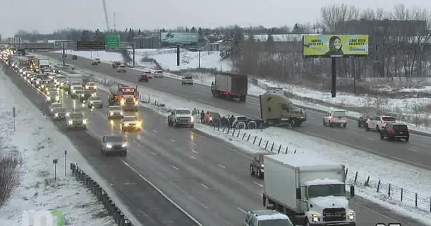
The Minnesota State Patrol logged roughly 220 vehicle crashes between 5 p. m. Wednesday and 10: 30 a. m. Thursday, including one fatality. Sixteen crashes resulted in injuries, another 188 vehicles went off state roads and emergency crews encountered 13 jackknifed semi trucks during that span. In the Twin Cities, main interstates were mostly plowed but ramps remained slippery and many secondary roads stayed snow-covered.
Schools closed and what residents saw
Dozens of schools across Minnesota closed or delayed classes Thursday, and the city of St. Paul declared a snow emergency. Local weather watchers reported a range of totals across suburbs and smaller cities: Edina 7. 5 inches, Mound 6. 5 inches, Excelsior 6. 3 inches, Owatonna 2. 5 inches and Lino Lakes half an inch. On the North Shore, some towns saw measured totals described as between 1 and 3 feet on other weather updates.
The storm moved in steadily Wednesday afternoon and into the evening commute, producing the bulk of the travel trouble that carried into Thursday morning. Light flurries were expected to taper through the day, and forecasters noted another system aimed at southeastern Minnesota and western Wisconsin was due to arrive in the evening; that follow-up storm was forecast to miss most of the Twin Cities metro.
The Minnesota tally of heavy snow and traffic incidents will guide recovery operations and road clearing through the day, with municipal crews focused on main arteries and state crews addressing interstates and jackknifed rigs. Officials have asked drivers to use caution on slippery ramps and covered secondary roads as plowing continues.
The next confirmed milestone is the evening arrival of a second system focused on southeastern Minnesota and western Wisconsin; snow there could affect travel later tonight.