


Weather Tomorrow: Storms Give Way to a Gradual Cooling Trend Into the Weekend
Planners and weekend travelers should note the latest local outlook: weather tomorrow will shift from a breezy, stormy Thursday night to a cooler, windy Friday and a chilly Friday night as temperatures trend down into the weekend.
Weather Tomorrow: Thursday night storms, SW winds
Thursday night will be breezy with scattered storms that are expected to end late. Forecast lows are in the upper 40s to low-50s, with southwest winds around 10–15 mph. That pattern creates a brief window of unsettled conditions before skies clear enough for the next-day transition.
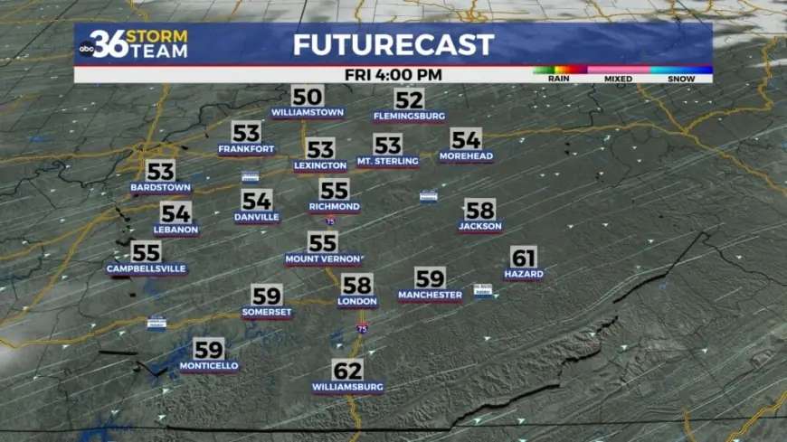
Friday turns mostly sunny and windy
On Friday, skies should be mostly sunny and windy, with highs in the mid-50s and west winds of 15–20 mph. The combination of sun and stronger west winds will mark a clear shift from the stormier Thursday night into drier, cooler air coming in behind the system.
Friday night: cooler and a touch of chill
Friday night will be a few clouds and chilly, with lows in the mid-30s and west winds easing to about 5–10 mph. The cooler nocturnal readings reflect the gradual cooling trend into the weekend, dropping several degrees from Thursday night lows.
Across Central Kentucky, the sequence — scattered storms late Thursday, then mostly sunny and windy Friday with cooler Friday night temperatures — sets up a weekend that begins cooler than the week’s peak readings. Residents planning outdoor activities should account for the wind and lower overnight temperatures.
The next confirmed forecast update will cover conditions for Saturday and beyond; meanwhile, Friday’s forecast shows highs in the mid-50s with west winds at 15–20 mph and a Friday night low around the mid-30s.