


Winter weather advisory in place as Maine braces for Friday evening snow; winter storm warning for parts of state
Calm, mild conditions on Thursday will give way to a faster-paced late-week storm system: a winter storm warning covers portions of the state while a winter weather advisory expands the area under travel concerns. Snow develops late Friday into early Saturday, with the heaviest snowfall and the most widespread impacts expected during the Friday evening commute.
Thursday: sunshine and mild temperatures before the change
Thursday will be the pick of the week, with plenty of sun and readings in the mid-to-upper 30s, climbing near 40 degrees in many inland spots (all times ET). Coastal communities may remain a touch cooler thanks to a weak sea breeze that could develop by the afternoon, and some minor snowmelt is possible along the shore. Overall, Thursday morning and midday travel should be uneventful.
Friday night into Saturday: timing, snowfall totals and where to expect it
Snow will begin to overspread the state in the late afternoon and evening hours on Friday, intensifying through the evening and into the night. The majority of snow is expected to move out by daybreak Saturday (ET), though pockets of lingering light snow are possible Saturday morning as conditions improve and the sun tries to reappear later in the day.
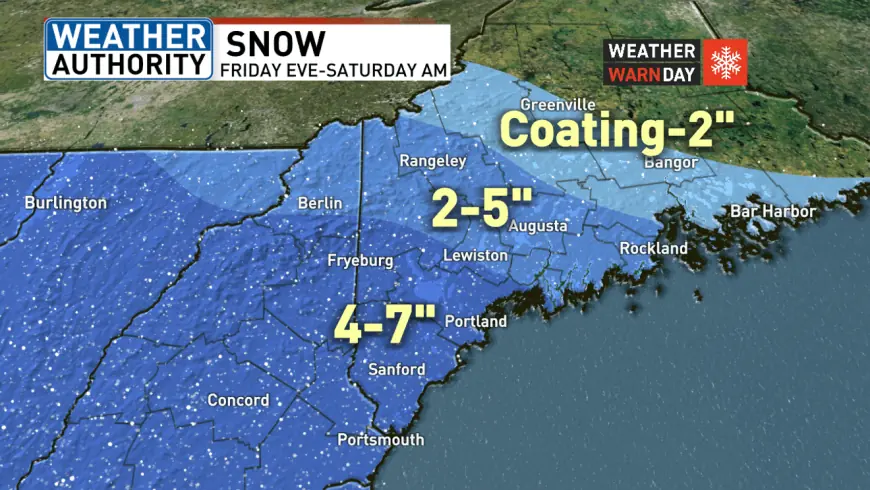
Forecast snowfall amounts are broken down by region: far western and southern Maine stand to receive about 4 to 7 inches. Interior and mountain areas are likely to pick up 2 to 5 inches, while a swath from Somerset County to Down East Maine could see a coating to 2 inches. Some of the heavier bands Friday night may produce wet, heavy snow at times.
Warnings, commute impacts and safety guidance
A winter storm warning is in effect for parts of the state, with a winter weather advisory covering additional counties. While Friday morning commutes are expected to be free of weather-related delays, the evening commute is the primary concern: snow will begin before many drivers finish their workday, becoming heavy at first and creating slippery roads and reduced visibility.
Travelers should plan for slower trips Friday evening and into the overnight hours. Road crews will be working through the night, and conditions should gradually improve by Saturday as snowfall tapers and some sunshine returns. Sunday looks milder and partly sunny, offering the best travel day of the weekend.
Residents should prepare now by charging devices, topping off vehicle fuel, and keeping emergency kits accessible. Those with essential travel during the expected heavy periods should consider delaying until roads improve. Monitor local advisories for any changes in timing or additional warnings as the system approaches.