


winter storm warning: Heavy snow returns to eastern Iowa Thursday as 6–8+ inch bullseye remains possible
A late-week storm is set to flip a brief spell of springlike warmth back to winter for eastern Iowa. Rain will move into parts of the state Thursday afternoon, then change to snow Thursday evening into the overnight hours. Winter Storm Warnings and Winter Weather Advisories are in effect for sections of eastern Iowa as forecasters increase confidence in a localized area of heavy snow.
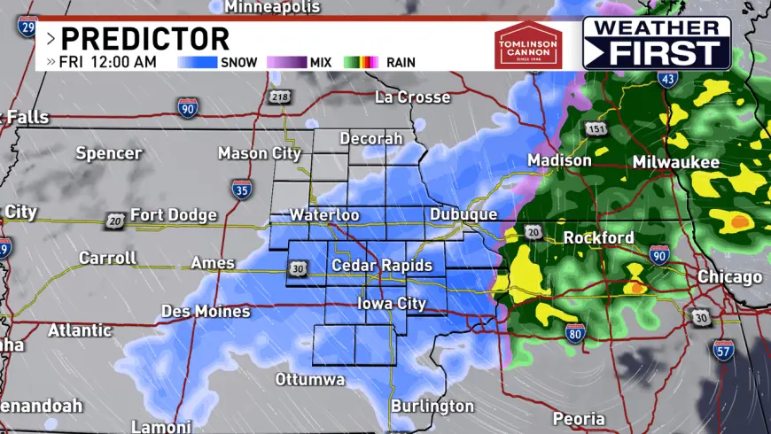
Storm timing and snowfall expectations
Rain will begin in spots after 1 p. m. ET Thursday, with a north-to-south changeover to snow expected after roughly 5–6 p. m. ET. The precipitation is forecast to continue into the overnight, with most snow tapering off by about 3–4 a. m. ET Friday.
Forecast guidance has trended a bit north, creating a corridor where dynamics and moisture could combine for heavy snowfall. One forecast signal points to a band north of a line from Waterloo to Prairie du Chien where 2 to 4 inches of accumulation is likely. In the core of the warning area, model agreement supports a heavier bullseye with potential accumulations of 6–8 inches or more in some locations.
Temperatures will be a few degrees of separation from one town to the next, so small changes in the track or thermal profile could shift totals. Areas south of the Waterloo–Prairie du Chien line will see lighter amounts, generally a trace to 2 inches, while the northern and eastern portions within the warning box face the greatest risk for significant snowfall.
Travel impacts, warnings and what to expect Friday
Drivers should prepare for slick and potentially snow-covered roadways Thursday evening into Friday morning. The rain-to-snow transition will create melting followed by refreezing and accumulating snow, producing treacherous travel conditions during the evening commute and into the overnight hours. Road crews will be active, but many routes may remain hazardous into Friday morning until plows can clear the heavier accumulations.
Winter Storm Warnings and Winter Weather Advisories cover the most at-risk counties, reflecting the split between a heavy-snow bullseye and lighter accumulations nearby. Wind will pick up as the system departs, making Friday breezy and enhancing blowing and drifting on open roads and rural stretches even after snowfall ends.
Residents are advised to allow extra time for travel, carry emergency supplies if heading out, and check local road updates before departing. With the storm ending in the early-morning hours Friday, expect ongoing cleanup and intermittent slick spots through the morning commute.
The developing system represents a sharp transition from the unusually warm start to February; overnight cooling and a shift in storm track are the drivers of this rapid change. Forecasters continue to monitor small shifts in the track and temperatures that could alter who sees the heaviest snow, so updates through Thursday evening will refine the zone of greatest impact.