winter storm warnings issued midwest as two-storm system pushes east

Forecasters warn that a sweeping two-storm pattern that has battered the West and Rockies is now bearing down on the Northern Tier and parts of the Midwest. Winter storm warnings issued midwest reflect an expanding threat of snow, freezing rain and damaging winds as the system accelerates eastward; heavy rain and flood concerns persist along the saturated West Coast.
Where the biggest impacts are expected
The initial storm has unloaded heavy snow across high elevations from the Sierra Nevada through the Rocky Mountains, while a trailing cold front and a second system over the Pacific Northwest have kept the West wet and windy. Mountain communities are seeing the heaviest totals: several feet of snow in parts of the Sierra Nevada and widespread 1–3 foot amounts on ridges of the Cascades and the Rockies.
As the storm complex progresses, a narrow ribbon of wintry precipitation is forecast to form near the Canadian border and push eastward. That line is expected to reach the northern Great Lakes by tonight and could arrive in southern New England by Wednesday afternoon (ET). Portions of the Upper Midwest and northern Plains already face strong wind gusts in excess of 45–60 mph in some locations, prompting high wind warnings and advisories that extend as far east as Illinois. In response, winter storm warnings have been expanded into parts of the Midwest where freezing rain, sleet and heavy wet snow are likely to disrupt travel and utility service.
Timing, hazards and safety steps
Travel disruptions are anticipated through midweek. The wintry corridor near the Canadian border is expected to intensify tonight and persist into Wednesday, with the combination of accumulating snow and gusty winds creating reduced visibility and slick roads. In lower elevations and urban areas, freezing rain and sleet could lead to dangerous black ice and widespread power outages where heavy glaze accumulates on lines and tree limbs.
Meanwhile, the West continues to contend with heavy rain and saturated soils. Coastal California and the Central Valley are seeing an additional 1 to 2 inches of rainfall in many locations, raising the risk of mudslides and urban flooding on terrain already soaked by recent storms. Flood watches and advisories remain in effect for vulnerable areas, and motorists are reminded to never drive through flooded roadways.
Officials urge residents in affected zones to prepare now: secure outdoor items, allow extra travel time, carry emergency supplies and consider postponing nonessential trips while warnings remain in effect. Those who must drive should be ready for sudden changes in conditions, and travelers should expect delays at airports and on interstates where storms intersect with heavy traffic.
Local impacts and recent incidents
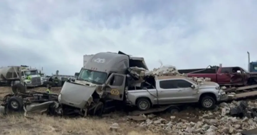
The volatile mix of rain, snow and wind has already produced serious consequences in the West. Dangerous conditions in the Rockies contributed to a large, fatal multi-vehicle crash in Colorado as winter precipitation and slick roads combined with heavy traffic. In California, intense rainfall is producing flash flooding threats in low-lying and urban areas and prompting alerts for residents in mountain and coastal communities.
With the system forecast to swing across the northern states, emergency managers in the Midwest and Great Lakes region are preparing for a fast transition from blustery wind events to wintry precipitation. Those under winter storm warnings should expect frequent updates on timing and intensity and factor severe weather into any travel or outdoor plans through the middle of the week.
National weather centers will continue to refine watches and warnings as the storm evolves; for now the guidance is clear: expect a dynamic and potentially disruptive stretch of weather from the West into the Midwest and beyond over the coming days (times listed in Eastern Time).


