


Daytona 500 weather: Hot, windy and rain likely to hold off for the race; severe storms possible Sunday night
Race-day conditions at Daytona International Speedway are expected to be hot and blustery, but the bulk of the rain threat should hold off long enough for the Daytona 500 to proceed. That window closes after sunset, when a line of strong to severe thunderstorms is forecast to move into Central Florida.
Race-day outlook at the track
Temperatures during the afternoon will climb into the 80s, with sustained south-southwest winds around 23–25 mph. Those winds will make the day feel warmer and could play a role in car handling and fuel strategy on the high banks. While a slim chance of spotty showers exists, the latest timing favors dry conditions through the bulk of the on-track action.
Even so, gusty conditions will be notable: expect periods of strong gusts during the afternoon, and teams should prepare for variable crosswinds that can affect drafting and exits out of the turns. Spectators should plan for heat and wind exposure and bring sun protection and layers for changing conditions.
Evening storm threat and timing
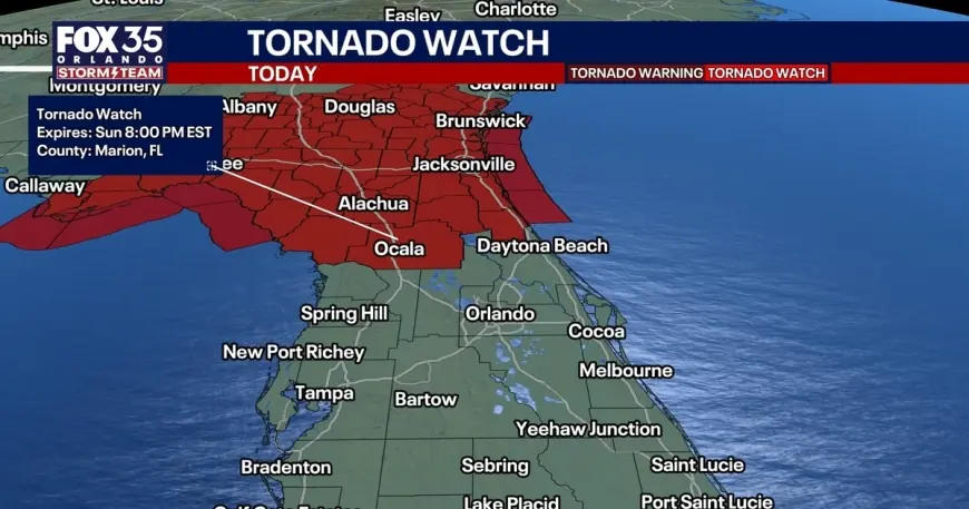
The most significant weather concern arrives after the race. The heaviest rain and thunderstorms are forecast to develop just after sunset, with the strongest activity expected between 7 p. m. and midnight ET. A tornado watch has been issued through 8 p. m. ET for multiple counties in northern and central Florida, including parts of Alachua, Flagler, Marion and Gilchrist, and spotty severe weather remains possible as the system moves through.
Main hazards with the evening storms will include damaging straight-line winds, heavy downpours that could produce flash flooding in low-lying areas, frequent lightning and a small risk of one or two tornadoes. Storm gusts are expected in the 45–55 mph range, with isolated gusts to 60 mph possible where stronger cells develop. Track and event officials will need to monitor the situation closely for any threats to spectator safety and on-site operations.
After the Sunday night thunderstorms move out, conditions should begin to dry. A brief cooldown is expected for President's Day, with highs settling into the lower to middle 70s for much of Central Florida, followed by a quick rebound later in the week as drier air and building high pressure return. Afternoon highs are then forecast to climb back into the lower to middle 80s later in the week.
For fans at the race: have a plan for shelter in case of lightning or severe gusts, heed instructions from on-site officials, and be prepared for hot, windy conditions during the daytime. Monitor local updates and be ready for a weather-driven change to evening travel plans if the line of storms shifts more quickly than expected.