


Tornado Watch in Effect as Texas Braces; Governor Activates State Emergency Resources
State officials activated emergency response resources as a powerful storm system moved into Texas, bringing the threat of severe thunderstorms, heavy rain, flash flooding, large hail, damaging winds and possible tornadoes. Residents across much of eastern Texas were placed under a tornado watch and urged to monitor conditions and prepare for rapidly changing weather.
State mobilizes ahead of expected severe weather
Gov. Greg Abbott directed the Texas Division of Emergency Management to activate state emergency response assets to support local authorities as storms move across the state. Officials emphasized that Texans should monitor road conditions before traveling, remain weather-aware, and have a plan in place in case of an emergency.
Resources were placed on standby to aid local response efforts. Emergency management officials also noted an elevated wildfire risk across parts of South, West and Northwest Texas into next week, underscoring the need for preparedness across multiple hazards.
Officials advised assembling an emergency supply kit, confirming evacuation or shelter plans for household members and pets, and keeping multiple ways to receive warnings and updates if power or communications are interrupted.
Watches, warnings and expected impacts
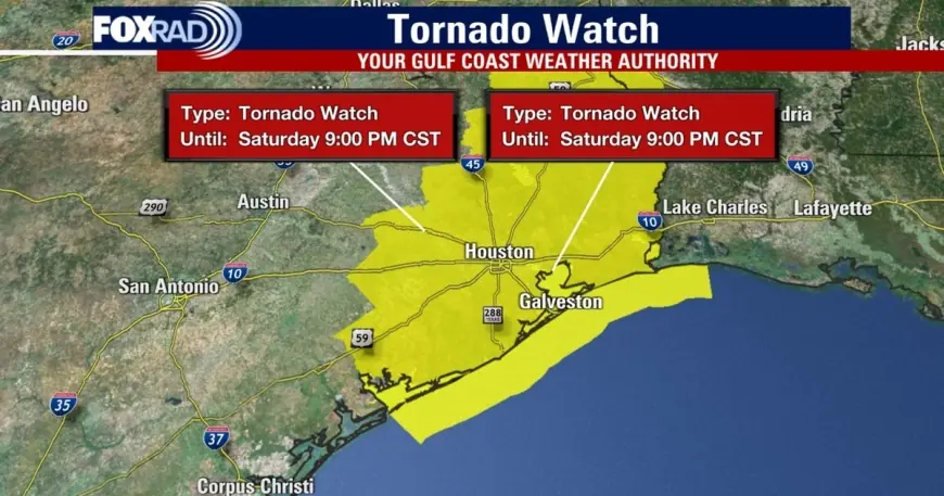
The National Weather Service issued a tornado watch that covered a large swath of the Houston-area and neighboring counties, with the watch in effect until 9 p. m. ET for numerous counties. The list included Angelina, Austin, Brazoria, Chambers, Cherokee, Colorado, Fort Bend, Galveston, Gregg, Grimes, Hardin, Harris, Harrison, Houston, Jackson, Jasper, Jefferson, Liberty, Marion, Matagorda, Montgomery, Nacogdoches, Newton, Orange, Panola, Polk, Rusk, Sabine, San Augustine, San Jacinto, Shelby, Smith, Trinity, Tyler, Upshur, Walker, Waller, Washington and Wharton.
By about 8: 00 p. m. ET, the tornado watch was canceled for much of the Greater Houston area, though it remained in effect for Chambers and Galveston counties until 9: 00 p. m. ET. Earlier in the evening, a tornado warning was issued for portions of Brazoria, Harris and Galveston counties from 6: 50 p. m. ET to 7: 15 p. m. ET as severe thunderstorms capable of producing tornadoes and extensive straight-line wind damage moved east at roughly 40 mph.
Wind gusts up to 60 mph were reported in some areas, with damage noted in the Pearland area and parts of Montgomery County. Two areas of particular concern in southeast Harris County were near Pearland and Rosharon as storms pushed toward the Gulf.
What residents should do now
Officials urged residents to stay tuned to local forecasts and follow guidance from local authorities. Immediate actions recommended include moving to an interior room on the lowest floor away from windows if a tornado warning is issued, securing loose outdoor items that can become projectiles in high wind, and avoiding travel if roads are flooded or debris-covered.
With heavy rainfall expected through the weekend in many locations, drivers should never attempt to cross flooded roadways. Flash flooding can develop quickly in urban areas and low-lying locations. Those with outdoor plans, including Valentine’s Day events, were advised to have alternate arrangements and remain prepared to shelter in place.
State and local emergency teams remain on alert. Residents are encouraged to prepare now so they can respond quickly if conditions worsen overnight or into the weekend.