


Gov. Abbott activates state emergency resources as tornado watch impacts parts of Texas
State officials have mobilized emergency response resources as a strong storm system moves across Texas, bringing a threat of severe thunderstorms, heavy rain, flash flooding, large hail, damaging winds and possible tornadoes. The threat began late Friday and is expected to expand east through the weekend, covering much of the eastern two-thirds of the state.
State response and emergency posture
Governor Greg Abbott has ordered the Texas Division of Emergency Management to activate state emergency response assets to support local officials. Emergency teams, equipment and personnel have been placed on standby to assist with storm impacts and post-storm recovery operations. Officials stressed that Texans should monitor road conditions before traveling, remain weather-aware and have an emergency plan in place.
Threat timeline and active watches and warnings (times ET)
The National Weather Service has outlined a multi-hazard setup that includes a risk for tornadoes in addition to damaging straight-line winds, large hail and heavy rainfall that could lead to flash flooding. The severe threat began later Friday and is expected to persist into the weekend.
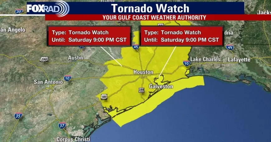
On Saturday evening, a tornado watch was issued for a broad swath of counties across the region and remained in effect for some areas until 9: 00 p. m. ET; other counties were removed from the watch around 8: 00 p. m. ET. At one point, a tornado warning was in effect for parts of several counties from 6: 50 p. m. ET to 7: 15 p. m. ET when storms capable of producing tornadoes and extensive straight-line wind damage were moving east at roughly 40 mph. Localized wind gusts of about 60 mph were measured in some areas, strong enough to damage roofs, siding and trees.
Forecast guidance highlighted two areas of particular concern in the evening convective line: locations near Pearland and Rosharon. The main window for the strongest storms was expected to open in the late-afternoon to evening hours—roughly beginning around 5: 00 p. m. ET northwest of the largest urban areas and sweeping toward the Gulf by about 10: 00 p. m. ET—but scattered strong storms could occur outside that window.
What residents should do now
Officials urge residents in threatened counties to stay tuned to local forecasts and follow direction from local authorities. Basic preparedness steps recommended for the public include assembling an emergency supply kit, creating or reviewing a family emergency plan, identifying a safe shelter location inside the home (a windowless interior room on the lowest floor), and avoiding travel during the worst of the storms.
Motorists should monitor road conditions and be prepared for sudden flooding on low-lying routes. If a tornado warning is issued for your area, seek shelter immediately in a substantial structure away from windows. After the storm, watch for downed power lines, debris and unstable structures before returning to impacted areas.
Emergency management officials also note an elevated wildfire risk across parts of South, West and Northwest Texas into next week in areas where storms have not produced widespread rainfall. Residents in those regions should remain vigilant for changing conditions.
State and local agencies remain on alert and will activate additional resources as needed. Residents are encouraged to keep mobile devices charged, maintain situational awareness through local briefings, and avoid hazards while emergency crews respond to storm impacts.