


State mobilizes emergency resources as tornado watch, warnings sweep southeast Texas
Texas officials activated state emergency response resources ahead of a line of severe storms that moved across the state Saturday evening, bringing heavy rain, damaging wind gusts, hail and tornado threats. Tornado watches and multiple warnings affected counties across the Houston region and beyond; times below are given in Eastern Time (ET).
State activates response teams and urges preparedness
Governor Greg Abbott directed the Texas Division of Emergency Management to put state resources on standby as the system tracked across the state. The governor said the state is prepared to respond and urged residents to monitor road conditions before traveling, stay weather-aware, and have an emergency plan ready. Emergency officials also flagged an elevated wildfire risk over parts of South, West and Northwest Texas into next week, even as storms pose an immediate flooding and wind threat.
State resources were readied to support local response and recovery efforts where needed. Officials encouraged Texans to assemble a basic emergency supply kit, confirm family communication plans, and remain near a safe shelter when severe weather approaches.
Tornado watch and warnings impact the Houston area Saturday evening
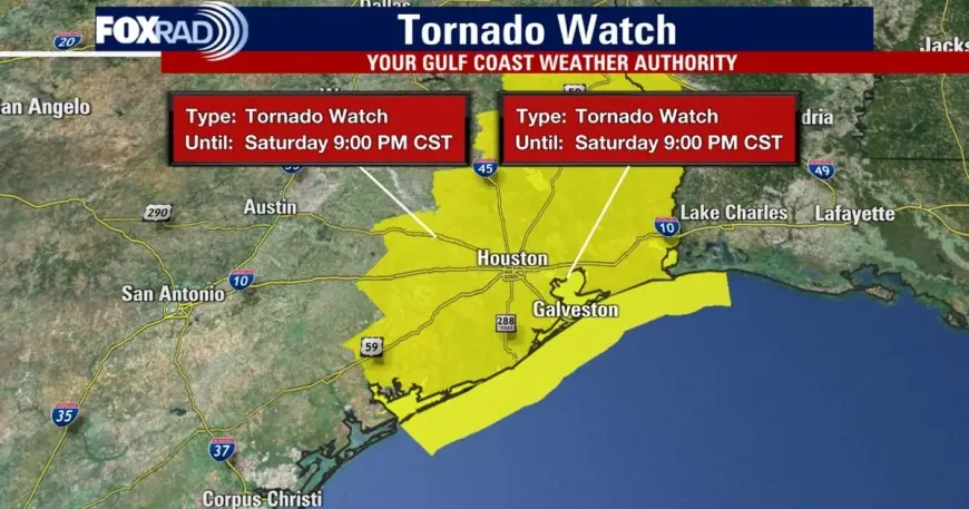
Officials issued a tornado watch covering many counties in southeast Texas for the evening; that watch was in effect through 9 p. m. CT (10 p. m. ET) for some coastal counties. In the Greater Houston area, the broader watch was lifted for most counties around 9 p. m. ET, while a watch remained in place for Chambers and Galveston counties until 10 p. m. ET.
Several tornado warnings and severe thunderstorm warnings were issued as storms progressed. One tornado warning covered parts of Brazoria, Harris and Galveston counties for the window of 7: 50 p. m. to 8: 15 p. m. ET, with storm motion roughly east at 40 mph. Local accounts and damage reports centered on areas near Pearland and Rosharon, where the line of storms produced embedded circulations and intense straight-line winds.
Wind gusts up to about 60 mph were reported in spots, capable of damaging roofs, siding and trees. Forecasters also noted the potential for large hail, flash flooding in heavy rainfall cores, and the possibility of isolated tornadoes embedded within the squall line.
What residents should do now
Residents in the watch or warning areas should move to a sturdy interior room on the lowest floor, away from windows, when a warning is issued for their location. If driving, avoid trying to outrun a storm; instead seek secure shelter and avoid flooded roadways. Flooding can develop rapidly in urban and low-lying areas, so do not attempt to cross flooded streets.
The primary window for the strongest storms began around 6 p. m. ET northwest of Houston and pushed toward the Gulf through about 11 p. m. ET. Individuals should keep multiple ways to receive warnings available—battery-powered radios, weather-alert devices, or mobile alerts—and follow guidance from local emergency managers and law enforcement for road conditions and sheltering instructions.
Emergency officials reiterated basic preparedness steps: finalize a family emergency plan, assemble a supply kit with water, nonperishable food, flashlights and medications, and secure loose outdoor items that could become projectiles in high winds. Texans are advised to stay tuned to evolving forecasts and be ready to take immediate action if warnings are issued for their area.