


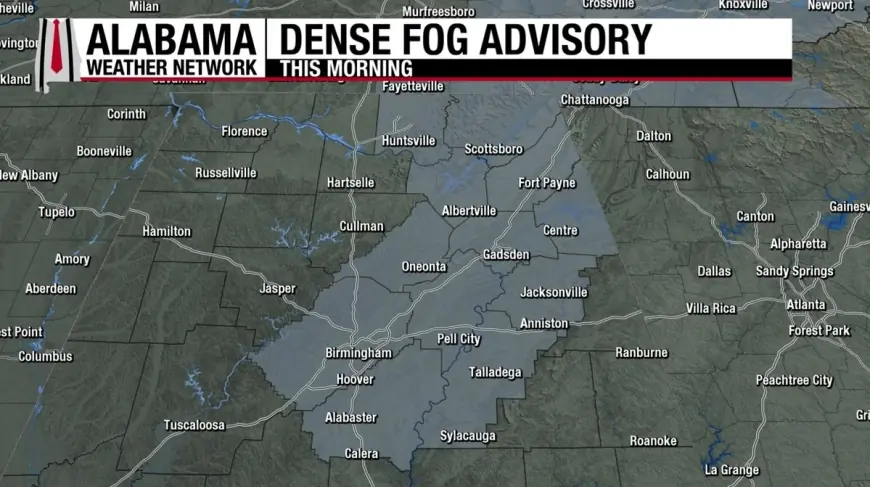
Dense Fog Advisory spreads across multiple regions on Feb. 8, complicating travel
A dense fog advisory was active in several parts of the U.S. early Sunday, February 8, 2026, with some areas seeing visibility fall to a quarter mile or less—thin enough to turn routine drives into chain-reaction risk. The impact has been most immediate on highways, bridges, and airport approach corridors, where fast-changing pockets of fog can leave drivers and pilots with little warning.
While fog is common in winter, Sunday’s setup has been notable for how many regions saw advisories at the same time, from interior valleys in California to the northern Plains and parts of the Gulf Coast.
Where Dense Fog Advisories were posted Sunday morning
In Northern and Central California, advisories covered multiple valley and shoreline zones around the San Francisco Bay area and parts of the Central Valley, with the most restrictive conditions concentrated in low-lying interior corridors where cold air pools overnight.
In the northern Plains, a dense fog advisory remained in effect across portions of central North Dakota, where widespread low visibility lingered through the morning as light winds and saturated near-surface air kept fog from mixing out quickly.
Along the western Gulf Coast, dense fog conditions also surfaced in the morning hours around the Houston area, with advisory language warning of rapidly changing visibility on major routes.
Because dense fog is highly localized, nearby towns can see very different conditions at the same time—clear skies on one stretch of road and near-whiteout conditions a few miles later.
Timing: when fog was expected to lift (ET)
Fog advisories typically expire when daytime heating, wind, or drier air helps visibility recover. On February 8, several advisory end times clustered around late morning into early afternoon in Eastern Time:
-
Bay Area interior valleys and shoreline zones: advisory timing in local listings ran into the morning hours, roughly aligning with around noon ET in many affected zones.
-
Houston area: advisory timing in local listings extended through mid-morning ET.
-
Central North Dakota: an advisory was set to run through early afternoon ET.
Even after an advisory expires, patchy fog can persist—especially near rivers, canals, farmland, and marshy ground.
Why the fog is so dense right now
Dense fog forms when air near the ground becomes saturated and water vapor condenses into tiny droplets that scatter light and crush visibility. Sunday’s broader fog footprint has been supported by a familiar winter pattern:
-
Long nights + calm winds: Clearer overnight periods and light winds let the ground cool rapidly, chilling the air right at the surface.
-
Moisture in the lowest layer: Recent or nearby moisture sources—wet soil, irrigation, coastal air, or lingering humidity—provide the water vapor needed for saturation.
-
Temperature inversions: Inversions trap cold, moist air in valleys and basins, preventing the vertical mixing that would normally disperse fog.
In coastal and bay regions, mild marine air over colder surfaces can also feed fog development, while inland valleys can hold fog like a lid until stronger sun or wind arrives.
What a “Dense Fog Advisory” means for visibility
A dense fog advisory is used when widespread fog reduces visibility to one-quarter mile or less. That threshold matters because it correlates with a sharp rise in crash risk: drivers lose the ability to see brake lights ahead, judge speed changes, or spot stopped vehicles until it’s too late.
Visibility can also vary minute to minute. A road may look manageable and then drop suddenly as you enter a fog bank—especially near overpasses, open fields, and low spots where fog thickens.
Safety steps for drivers this morning
If you must drive in fog, the most important goal is to avoid outrunning your headlights and to keep other vehicles aware of your position. Practical steps include:
-
Slow down early before entering a thicker patch; drive at a speed that matches what you can see.
-
Use low-beam headlights (high beams can reflect off fog droplets and worsen glare).
-
Increase following distance and avoid sudden braking.
-
Stay in your lane and use the right-edge line as a guide if visibility drops sharply.
-
Avoid passing unless absolutely necessary.
-
If you must stop, move as far off the road as possible; stopped vehicles in fog are a major collision hazard.
For travelers, the simplest rule is timing: if you can delay a trip until late morning or early afternoon, that often avoids the worst visibility window.
Sources consulted: National Weather Service, NOAA, Houston Chronicle, Fresno Bee