


Gulf Coast Braces for Harsh Winter Cold Snap
As the Gulf Coast braces for an intense winter cold snap, an Extreme Cold Warning has been issued. This Arctic outbreak is expected to bring dangerously low temperatures and severe winter conditions throughout the Southeast this weekend.
Forecasted Temperatures and Wind Chill
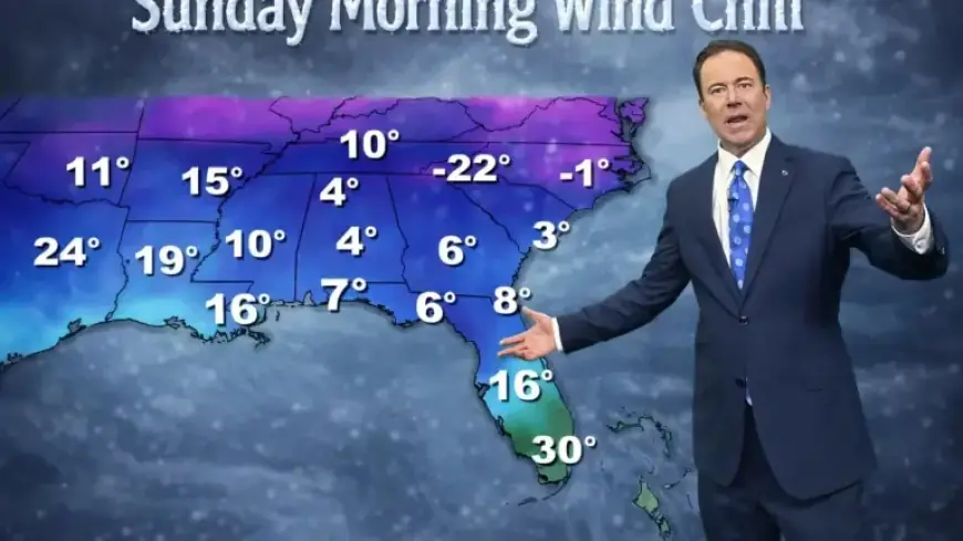
According to the National Weather Service (NWS) in Mobile, Alabama, wind chills in the teens are anticipated on Saturday and Sunday mornings. Some areas may even experience wind chills dipping into single digits.
Wind Advisory Details
- Advisory Duration: 6:00 AM – 9:00 PM on Saturday
- Expected Wind Speeds: Northwest winds of 15 to 25 mph
- Wind Gusts: Up to 40-45 mph
Impact on Temperatures
This cold snap will lead to very low temperatures across North Florida and the Gulf Coast. Expected air temperatures are forecast to start in the 20s, only rising to the middle 30s. Some areas may struggle to reach freezing.
Winter Conditions and Their Hazards
A hard freeze is expected, which may severely impact plants, pipes, and agriculture. Additionally, hazardous marine conditions are likely due to strong offshore winds and rough seas. A gale warning remains in effect, indicating dangerous conditions at sea.
Travel Conditions
Elsewhere, a developing winter storm threatens the Carolinas and nearby states with moderate to heavy snowfall. This could result in hazardous travel, power disruptions, and possible impacts on local events.
The precise amount of snowfall is contingent on the positioning of low pressure over the Atlantic Ocean. Even regions receiving lighter snow may face icy roads, particularly on bridges and untreated surfaces.
Looking Ahead
After facing these frigid conditions, warmer weather is predicted to return to the Gulf Coast by Tuesday and Wednesday, with highs expected to reach the 60s.