


Heavy Rainfall Hits, Yet More Showers Needed
Moderate rains fell across much of eastern Nebraska Wednesday into Thursday. Eastern counties reported roughly an inch of rain, while the western half saw little of the heavier precipitation.
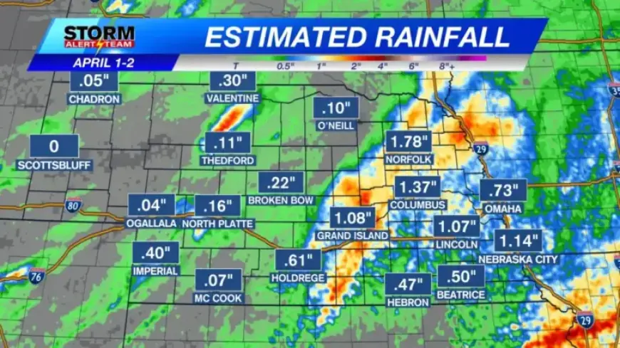
Rainfall recap
Heavy rainfall affected a broad swath of the state on Wednesday and Thursday. The western region largely missed those totals.
Communities in southeast and central Nebraska reported the highest amounts. Cities include Lincoln, Grand Island, Kearney, Hastings, Columbus, Beatrice, Crete, Seward, York, Fairbury, Broken Bow, Ord, and McCook.
Storm chances this week
The next rain chance arrives Friday afternoon in far eastern Nebraska. Forecasters expect a narrow line of storms to try to form there.
Storms are forecast to move east quickly. That rapid motion will raise the threat for severe weather in short order.
Severe risk
Iowa and Missouri are under a level 3 Enhanced Risk for severe storms Friday evening. Nebraska may see increases in severe potential as the line progresses east.
Drought status
The latest Drought Monitor shows most of Nebraska in Severe to Extreme Drought. The midweek rain fell after that map was issued.
Officials will reassess next week to see if conditions improved. More showers are needed in many western and central areas to ease the drought.
Short-term temperatures
Readings turn chilly for the next two days. Highs on Friday will range from the 30s to the 40s across eastern Nebraska.
Temperatures climb into the 50s and 60s on Saturday. A warmer Easter Day is expected before cooler conditions return early next week with additional rain or mixed precipitation chances.
Report by Filmogaz.com. Chief Meteorologist Rusty Dawkins provided the forecast details.