


Black Ice, Heavy Frost Persist in Tuesday’s Cold Weather Forecast
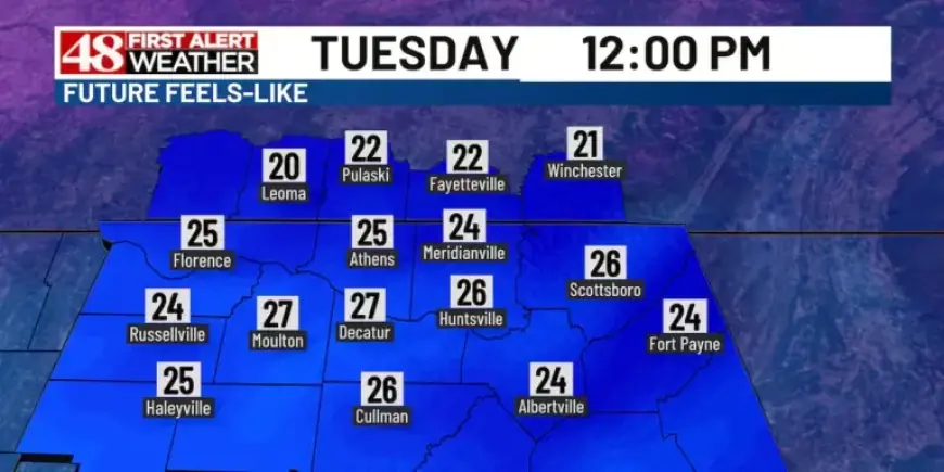
The weather forecast for Huntsville, Alabama, indicates a cold start to the week. On Tuesday, residents should prepare for significant frost that developed overnight. For those who drive, allocating an extra 5 to 10 minutes to scrape windshields is advisable.
Cold Weather Conditions
In addition to heavy frost, patches of black ice are anticipated on the roads, especially on elevated surfaces like bridges and overpasses. Caution is paramount as this type of ice is notoriously challenging to detect.
Morning Temperatures
- Single-digit to low teens temperatures expected in the morning.
- Residents advised to dress warmly and in layers.
Daytime Forecast
The day will be predominantly sunny across the Tennessee Valley. Breezy winds from the west-southwest will bring a slight warming effect, pushing the afternoon highs into the upper 30s, nearing 40 degrees.
Overnight and Wednesday Forecast
Cloud cover is set to return overnight, keeping morning temperatures slightly warmer in the teens to lower 20s. Homeowners should continue to let their faucets drip to prevent pipes from bursting in this extreme cold.
Another round of heavy frost is expected on Wednesday morning, with the day itself being partly to mostly cloudy. High temperatures are projected to reach the lower 40s.
Upcoming Temperature Trends
The trend for the week shows a gradual decline in temperatures. Thursday will remain mostly cloudy with highs around 43 degrees. By Friday, temperatures will drop to the mid-30s, and a more significant temperature decrease is forecast for the weekend.
- Saturday’s high expected to be in the mid-20s.
- Weekend morning lows will likely remain in the low teens.
Stay tuned to Filmogaz.com for the latest updates on this winter weather and more.