


Atlanta Weather Forecast: Winter Storm Georgia Threat Brings Ice Storm Risk Sunday, With Snow in North Georgia
Atlanta weather is turning sharply more dangerous this weekend as a high-impact winter storm targets Georgia with a heavy emphasis on ice. The highest-confidence threat for metro Atlanta is freezing rain and sleet beginning late Saturday and intensifying Sunday, with hazardous travel and pockets of power outages possible where ice loads grow. Snow is more likely north and northeast of the city, where colder air holds longer and wintry precipitation falls more steadily.
For most residents, the question isn’t just “Will it snow in Georgia?” It’s “How bad will the ice storm in Atlanta get?” Ice is the bigger risk for interstates, bridges, trees, and power lines—especially if rain transitions to freezing rain while temperatures sit at or below 32°F for several hours.
-
Metro Atlanta faces a meaningful risk of freezing rain and sleet Sunday, creating dangerous travel and scattered power outage potential.
-
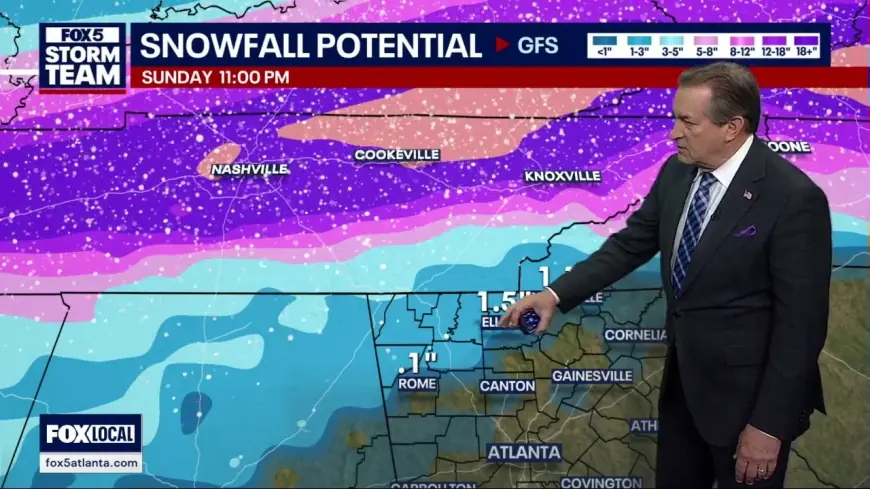
North Georgia has the best chance for measurable snow/sleet accumulation, while areas south of the metro lean more toward cold rain with periods of ice.
-
Timing points to late Saturday into Sunday as the primary impact window, with lingering hazards into early Monday due to refreezing.
-
The highest-impact outcomes depend on a narrow temperature “sweet spot” near freezing—small shifts can flip a forecast from slushy to crippling.
-
If you must drive, the most treacherous time is often overnight and early morning when roads glaze before crews can catch up.
Winter storm Georgia timeline: when conditions turn in Atlanta
The weekend unfolds in stages. Saturday begins as a setup day: temperatures drop, winds increase, and the atmosphere loads moisture ahead of the storm’s core. Late Saturday (especially Saturday night), precipitation expands into Georgia. The most likely evolution for metro Atlanta is a transition from rain to a wintry mix as colder air deepens near the surface.
Sunday is the main event. Periods of freezing rain and sleet become more likely across North Georgia and the Atlanta metro, with heavier wintry precipitation north of the city. In many winter storms, the “worst” is not when flakes are falling—it’s when freezing rain quietly builds a glaze layer that turns every road surface into a skating rink.
Even if precipitation eases late Sunday night, the cold that follows can lock in impacts. Refreezing Monday morning can turn previously wet roads into black ice, extending travel problems beyond the storm’s last radar echoes.
Ice storm Atlanta risk: what “significant ice” means in real life
Ice storms are disruptive at relatively low amounts. A light glaze can cause multi-vehicle crashes, close ramps, and turn sidewalks into hazards. As ice thickens, the concern shifts to infrastructure: tree limbs snapping, lines sagging, and power failures.
For metro Atlanta and nearby suburbs, the main risk Sunday is a period where temperatures hover right around freezing while steadier precipitation continues. That combination favors accretion—ice building on exposed surfaces. The “destructive” label that forecasters sometimes use is tied to how rapidly ice can accumulate when rain keeps falling and the surface stays below 32°F.
In practical terms, if the storm leans icier than snowier in the metro, expect:
-
Rapidly worsening roads, especially on elevated routes and overpasses
-
Slower emergency response as crashes multiply
-
Localized power issues where trees are already stressed or where ice builds for several hours
Snow in Georgia: where snow is most likely Sunday
If you’re looking for the best snow chances, aim north. The colder air tends to hold longer across far North Georgia and higher elevations, supporting snow and/or sleet accumulation—sometimes mixed with freezing rain depending on the exact temperature profile.
Areas generally favored for more snow and sleet include:
-
Counties north of the Atlanta metro, particularly closer to the state line
-
Higher-elevation corridors where cold air is stubborn and precipitation falls harder
Inside metro Atlanta, snow may still appear at times, but the more consistent threat is a mix dominated by freezing rain and sleet—precipitation types that can look less dramatic than snow while causing more damage.
Macon GA weather: what to expect south of Atlanta
Macon GA weather this weekend sits closer to the storm’s warmer edge, so the forecast leans more toward cold rain at times. Still, periods of freezing rain or sleet remain possible—especially if colder air pushes south faster than expected overnight or early Sunday.
The key for Macon and surrounding areas is timing and temperature. If precipitation arrives while temperatures are still above freezing, impacts are limited. If precipitation persists into a sub-freezing window, even brief icing can be enough to create travel trouble on bridges and untreated roads.
Why this storm could overperform: the “near-freezing trap”
Georgia winter storms often hinge on tiny temperature differences. A shift of 1–2 degrees, or a change in the timing of the coldest air, can redraw the ice and snow map dramatically.
Two factors to watch:
-
How quickly temperatures fall Saturday night as precipitation spreads in
-
Whether the cold air remains locked in Sunday while precipitation stays steady
If the cold locks in and the precipitation stays strong, the ice risk rises quickly. If warmer air noses in sooner, ice amounts drop, but slushy roads can still refreeze later.
A short historical context: Georgia’s most disruptive winter events frequently involve ice rather than deep snow. The region’s limited road treatment capacity for prolonged icing, combined with widespread trees near power lines, can turn a “moderate” winter storm into a multi-day disruption.
FAQ
Will it snow in Atlanta on Sunday?
Snow is possible at times, but the bigger risk in the metro is freezing rain and sleet, which can be more dangerous than snow.
When is the worst weather expected in Georgia this weekend?
Late Saturday into Sunday looks like the highest-impact window, with lingering hazards into Monday morning due to refreezing.
Is Macon likely to see snow?
Macon is more likely to see cold rain with a chance of sleet or freezing rain if temperatures drop fast enough, but it’s closer to the storm’s warmer side.
The most useful plan is to prepare for ice first: assume roads will deteriorate quickly Sunday, avoid unnecessary driving, and be ready for spotty power issues in the hardest-hit areas. The forecast will sharpen as the storm arrives, but the overall direction is clear—Atlanta weather this weekend carries a real winter-storm punch, and the safest move is to treat Sunday as a high-risk travel day.


