


Polar vortex forecast meets NJ weather: snow prediction this weekend for Jersey and Long Island, plus how many inches today
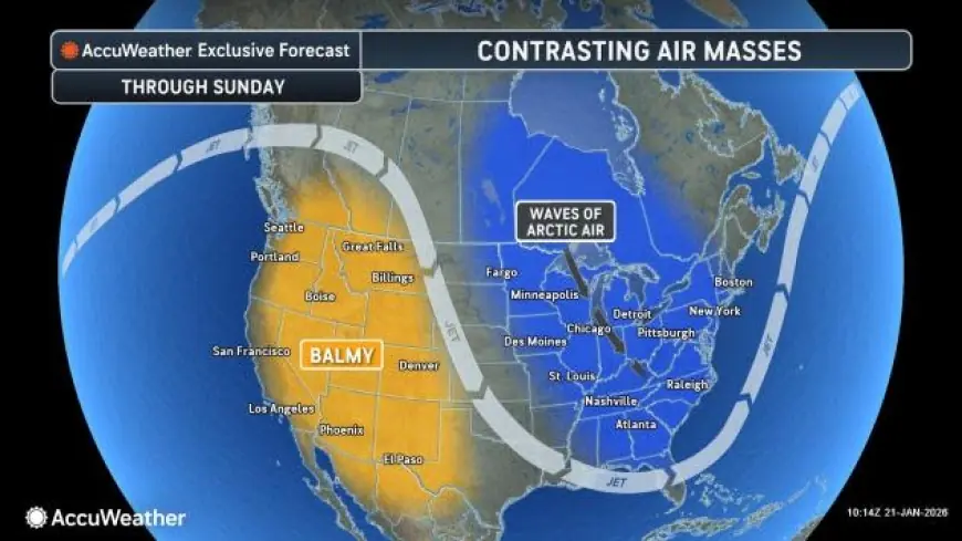
A sharp push of Arctic air is setting up a bitterly cold weekend across New Jersey and Long Island, with the best chance for accumulating snow arriving late Sunday into early Monday (January 25–26, 2026). The same setup that drags temperatures down into the teens will also support a period of light-to-moderate snow, with totals generally in the 2–5 inch range depending on where the steadier band sets up.
For today (Thursday, January 22), any snow around North Jersey looks more like brief light snow or flurries with little to no accumulation, before colder air arrives tonight and Friday.
NJ weather and snow forecast this weekend: timing and expected totals
The weekend story has two chapters: the cold arrives first, then the snow.
Saturday (January 24) turns frigid and increasingly cloudy, with daytime highs only in the teens to low 20s. That cold is important because it sets the stage for snow to stick quickly once it starts. The more meaningful snow signal shows up Sunday (January 25), with snow continuing into early Monday (January 26), then tapering to lighter snow or flurries.
-
Today (Thu 1/22): Mostly quiet overall; any snow is light and not expected to pile up.
-
Friday (1/23): Breezy and colder, setting up the weekend freeze.
-
Saturday (1/24): Very cold; conditions prime for any precipitation to stick.
-
Sunday into early Monday (1/25–1/26): Snow and slick travel, then lingering light snow/flurries.
Key takeaways
-
The cold surge arrives first, with highs dropping into the teens/low 20s by Saturday.
-
The main snow window is late Sunday into early Monday.
-
General snow totals: about 2–4 inches for much of North/Central Jersey, and about 2–5 inches for parts of Long Island.
-
Travel impacts are likely Sunday night into Monday morning as roads and sidewalks turn snow-packed and slippery.
-
The cold is serious: lows near or below 10°F this weekend into early next week, with extra risk for frozen pipes and dangerous wind chills.
Snow prediction for this weekend: how many inches for Jersey and Long Island?
Here’s the practical “how many inches” snapshot for the core areas people ask about:
| Area | Main snow window | Expected accumulation |
|---|---|---|
| Newark / North Jersey | Sun 1/25 into early Mon 1/26 | ~2–4 inches (storm total range) |
| Long Island (central, e.g., Islip area) | Sun 1/25 into early Mon 1/26 | ~2–5 inches (storm total range) |
These numbers can shift if a heavier snow band sets up over one corridor for a few hours, but the baseline message is a plowable event rather than a blockbuster—paired with very cold temperatures that keep surfaces icy and slow melting.
How many inches of snow today?
For Thursday, January 22, measurable snow looks unlikely for most of New Jersey and Long Island. North Jersey may see a brief period of light snow early, but the expectation is little to no accumulation—think trace to a coating at most in spots that catch a quick burst before skies trend quieter.
If you’re trying to plan errands: today is the easier day. The tougher period is Sunday night into Monday morning when snow and cold overlap.
Polar vortex forecast: is this “the polar vortex” or just Arctic air?
In everyday terms, this pattern will feel like a polar vortex outbreak because it’s delivering a deep shot of Arctic air, with daytime highs struggling and nighttime lows dropping toward single digits in some spots. Whether meteorologists label it a classic “polar vortex” event depends on how the upper-level circulation is behaving, but for daily life the impacts are the same: dangerously cold air, faster freezing on untreated roads, and a higher chance of burst pipes.
What makes this setup tricky is that even modest snowfall becomes more disruptive when temperatures stay in the teens and 20s—salt works less efficiently, and refreeze happens fast.
A quick historical note: late January in the Northeast often features the season’s harshest cold shots. When that cold arrives ahead of a snow window, the snow sticks immediately and road conditions can deteriorate quickly, even with totals that would otherwise be manageable.
What to watch next (especially if you rely on local TV-style updates)
Two “last-mile” details will decide who ends up on the high end of totals:
-
Where the steadiest snow band organizes Sunday night.
-
How quickly winds pick up, which can blow snow around and lower visibility even with moderate accumulation.
If later updates trend colder and slightly wetter at the same time, totals can tick upward. If the moisture is lighter or the snow ends earlier Monday, totals settle closer to the low end.
By Monday, the snow should be winding down, but the cold lingers into early next week—so the bigger follow-up issue is ice and refreeze rather than new heavy snowfall. Keep an eye on Sunday night travel, protect exposed plumbing, and plan for a slower Monday morning commute if you’re in Jersey or on Long Island.