


Midday Update: Winter Storm Threatens Snow and Ice for Alabama
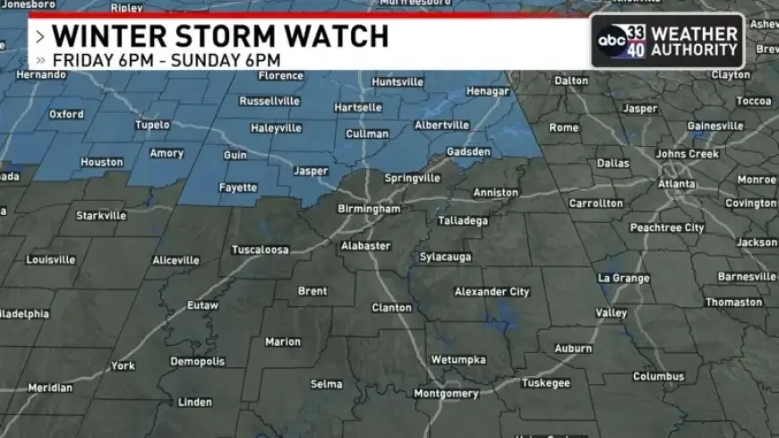
BIRMINGHAM, Ala. – A Winter Storm Watch has been issued for North Alabama and parts of southern Middle Tennessee. This potentially significant weather event is forecast to impact the region from Friday evening through Sunday afternoon.
Areas Affected by Winter Storm Watch
The Winter Storm Watch covers a range of counties, including:
- Lauderdale
- Colbert
- Franklin
- Lawrence
- Limestone
- Madison
- Morgan
- Marshall
- Jackson
- DeKalb
- Cullman
- Lincoln (TN)
- Franklin (TN)
- Marion
- Lamar
- Fayette
- Winston
- Walker
- Blount
- Etowah
- Cherokee
Potentially Impacted Cities
Key cities that may experience the effects of this winter storm include:
- Huntsville
- Florence
- Muscle Shoals
- Decatur
- Athens
- Scottsboro
- Fort Payne
- Cullman
- Gadsden
- Jasper
- Hamilton
- Fayette
- Guntersville
- Arab
- Albertville
Forecast Details
According to meteorologist James Spann, the forecast for the weekend is complex. Freezing rain is expected to begin across Northwest Alabama on Saturday morning. Temperatures are anticipated to range from 27 to 32 degrees, with ice accumulation likely through midday.
By Saturday afternoon, temperatures are expected to rise to the mid to upper 30s, potentially easing icing conditions. The European global model indicates that a warm sector may keep much of North Alabama above freezing from Saturday afternoon until early Sunday morning.
Cold Air Damming and Precipitation Patterns
A cold air damming (CAD) pattern may lead to freezing rain issues in Northeast Alabama Saturday night. Areas like Jackson, DeKalb, Cherokee, and Cleburne could be impacted. Meanwhile, the southern regions will likely see mostly rain during this time.
Temperatures will decrease rapidly on Sunday as the surface low moves northeast, with a possibility of snow or freezing rain on the back end of the precipitation mass on Sunday afternoon. The northern half of Alabama may experience temperatures dropping to between 10 and 18 degrees by Monday morning.
Safety Concerns During Winter Storm
Drivers should be mindful of potential black ice on roads Sunday night into Monday morning. Much of North Alabama will experience sub-freezing temperatures all day Monday, despite the return of sunshine.
Key Takeaways
- Winter Storm Watch in effect for northern Alabama.
- Ice accumulation expected in Northwest Alabama on Saturday.
- Freezing rain likely in Northeast Alabama Saturday night.
- Black ice possible on roads Sunday night and Monday morning.
Weather forecasts can change, so residents are encouraged to stay updated for the latest information from Filmogaz.com.