


Cincinnati Weather Update: Wintry Mix Wednesday Morning, Then a Sharp Turn Into Bitter Cold and Weekend Snow Potential
Cincinnati is riding a fast-changing winter pattern this week: a light wintry mix early Wednesday gives way to a breezy, milder afternoon, then temperatures slide steadily colder into Friday before the weekend brings another chance for snow and the coldest air of the stretch. The biggest impacts are timing and temperature swings—slick spots early, then wind, then a freeze that can catch drivers and homeowners off guard.
After a relatively manageable Wednesday, the real headline becomes the late-week cold: daytime highs fall into the 20s by Friday, with overnight lows dropping into the single digits, and wind chills dipping well below that in exposed areas.
Cincinnati weather today: what to expect on Wednesday, January 21
Wednesday starts with a brief window for light snow or a wintry mix, especially around the morning commute, before precipitation tapers and temperatures climb. Even “a little accumulation” can create isolated slick bridges and untreated side streets, so the early hours are the time to be most cautious.
By midday and afternoon, Cincinnati trends mostly cloudy and breezy, with highs near 40–42°F. Winds turn gusty at times, which can dry some pavement but also make the air feel colder than the thermometer suggests. Wednesday night slips back into the upper 20s, setting the stage for refreeze where roads stayed wet late.
-
Light snow or wintry mix is most likely early Wednesday, then conditions improve.
-
Afternoon highs rebound to around 40–42°F, but it stays breezy.
-
Gusty winds can produce quick temperature swings and patchy refreeze risks after sunset.
-
The colder air strengthens Thursday night into Friday, bringing the week’s lowest wind chills.
-
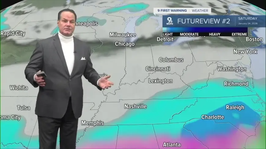
Another round of snow chances returns Saturday into Sunday, with frigid temperatures persisting.
The cold surge: why Friday is the week’s turning point for Cincinnati weather
Thursday is a transition day—brighter at times but cooler, with highs in the mid-30s and increasing signs that Arctic air is pressing in. The more dramatic change arrives Thursday night into Friday.
Friday looks notably colder, with highs in the mid-20s and lows dropping into the single digits. That combination matters because it changes the “rules” for everything from driving to home maintenance. Salt effectiveness falls as temperatures plunge, small wet spots become sheet ice quickly after dark, and exposed pipes face higher freeze risk.
If you’re planning early morning travel on Friday, budget extra time and expect the cold to be the main hazard—even if there’s no major snowfall at that moment.
Weekend snow potential: Saturday and Sunday bring another hazard window
Saturday into Sunday is the next period to watch closely. A weaker winter system could bring intermittent snow and flurries Saturday afternoon into Sunday, with light accumulations possible. In a frigid setup, even modest snowfall can create outsized impacts, because roads struggle to clear and any melting/refreezing cycles can turn slush into hard-packed slick spots.
Sunday also looks like one of the most uncomfortable days to be outside for long stretches. With highs stuck in the teens and lows near the single digits, wind exposure becomes a real concern for anyone working outdoors, waiting at bus stops, or attending events.
Practical impacts around Cincinnati: travel, schools, and home safety
This week’s pattern is less about one blockbuster storm and more about multiple smaller “impact moments”:
Commuting:
-
Wednesday morning: watch bridges, ramps, and shaded roads for quick icing.
-
Thursday night into Friday morning: refreeze and bitter wind chills.
-
Saturday–Sunday: snow showers plus very cold pavement can lead to lingering slick spots.
Home and car:
-
Keep the gas tank at least half full going into the coldest nights.
-
If you’re in an older home or have exposed plumbing, let faucets drip lightly during the coldest hours and open cabinet doors under sinks to warm pipes.
-
Bring pets inside and check outdoor water bowls often; they freeze fast in single-digit lows.
Health:
Cold this sharp can aggravate asthma and heart conditions, and wind chills can cause skin to lose heat rapidly. Dress in layers, cover hands and ears, and limit long outdoor exposure on Friday through Sunday.
Mid-January in the Ohio Valley often features these “whiplash weeks,” where a brief warm-up is followed by a hard freeze. The setup is familiar: mixed precipitation on the leading edge, gusty winds behind it, then cold settling in long enough to turn small hazards—wet pavement, a light snow shower—into bigger problems.
FAQ: Cincinnati weather this week
Will Cincinnati get significant snow this week?
The most likely snow windows are early Wednesday (light) and again Saturday into Sunday (light to locally moderate). Impacts can still be high because temperatures stay very cold.
When is the coldest stretch?
Late Thursday night through Sunday looks coldest, with Friday and the weekend bringing teens for highs and single digits for lows.
What’s the biggest travel risk?
Not just snowfall—refreeze is the sneaky hazard. Wet roads can turn icy quickly after sunset, especially Thursday night and again over the weekend.
Looking ahead, the key signals are whether weekend snow coverage expands and how strong the wind stays during the coldest period. If winds remain active, wind chills will be the primary problem even on days with little precipitation. If the weekend snow bands grow more organized, travel impacts could increase quickly—especially because the cold will keep roads from “recovering” between bursts.


