


Snow Storm in Russia: Kamchatka Buried Under Historic Snow as Back-to-Back Blizzards Trigger Widespread Disruption
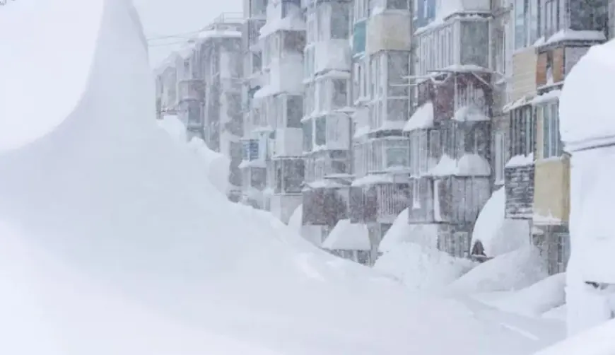
A major snow storm in Russia is gripping the country’s Far East, where the Kamchatka Peninsula has been overwhelmed by a rare combination of extreme snowfall, high winds, and relentless storm “reloads” that have left towns digging out day after day. In and around Petropavlovsk-Kamchatsky, snowdrifts have climbed to the height of cars and, in some neighborhoods, up to the level of first-floor windows—turning routine commutes into tunnel-like walks between towering snowbanks.
This isn’t a single overnight dump. It’s a multi-week accumulation problem that has pushed local services into emergency mode, with residents and crews racing to keep roads open, clear building entrances, and reduce rooftop hazards before the next burst arrives.
Why the snow storm in Russia is hitting Kamchatka so hard
Kamchatka’s winter weather is often severe, but this stretch stands out for two reasons: the totals and the persistence. December already delivered exceptional snow depth across parts of the peninsula, and early January piled on even more—adding up to a cumulative burden that’s difficult to manage no matter how winter-ready a region is.
The storm pattern has repeatedly done three things at once:
-
Dropped heavy snow faster than plows can fully clear it
-
Pushed strong winds that re-stack cleared snow into deep drifts
-
Compressed the snowpack, making each round harder to move and more dangerous on structures
When snow removal can’t “catch up,” the challenge shifts from cleanup to maintaining a narrow corridor of basic functionality: emergency routes, main arteries, and access to critical services.
Petropavlovsk-Kamchatsky impacts: roads, transport, and daily life
The most visible disruption has been mobility. Streets that normally handle two-way traffic can narrow into single lanes bounded by tall plow piles. Parking becomes a guessing game, and vehicles left in place can be swallowed quickly by drifting snow—then locked in by hard-packed berms.
Common effects in the region during the heaviest phases include:
-
Delays and restrictions on local transportation
-
Slowdowns on key roads as crews prioritize main corridors
-
Access issues to buildings as entrances and stairwells become blocked
-
Strain on emergency response as visibility drops and lanes tighten
Even after snowfall eases, the city doesn’t “return to normal” right away. Wind can continue sculpting drifts, and the physical effort required to keep entrances clear becomes a daily necessity for residents.
The hidden danger: ice, rooftops, and falling snow
Deep snow brings a second wave of risk once it starts loading rooftops and overhangs. Wet, compacted snow can become dangerously heavy, and shifting temperatures or gusty winds can trigger sudden slides from roofs—especially in built-up areas where repeated thaw-freeze cycles change the snow’s structure.
Key hazards authorities typically warn about in these conditions:
-
Falling snow and ice from roofs and awnings
-
Blocked exits and reduced visibility near building edges
-
Stress on structures from uneven accumulation
-
Localized power interruptions if lines are affected by weather and debris
In severe winters, the most serious incidents often happen during the “between storms” window, when people venture out to clear snow and risk being in the wrong place at the wrong time near overloaded roofs.
How extreme are the totals? What the January 2026 snowfall means on the ground
The standout feature of this event is cumulative depth. Early January snowfall added more than two meters in parts of the peninsula after an already extraordinary December, producing snow walls and drifts that behave like temporary terrain. When snow reaches this scale, normal operations change:
-
Plowing becomes continual maintenance rather than a one-time clearing
-
Clearing snow requires hauling it away, not just pushing it to the side
-
Side streets and residential zones can stay constrained far longer than main roads
-
Supplies and deliveries become more fragile if a single corridor closes
In short: the storm’s impact isn’t only what falls from the sky—it’s the backlog it leaves behind.
Weather news reality check: viral videos vs verified footage
As images of buried cars and “snow canyons” spread online, some clips circulating with the story have been exaggerated or misattributed. Verified visuals from Kamchatka are dramatic enough on their own, but it’s still worth treating the most unbelievable videos with caution—especially those showing impossible snow depths or scenes that don’t match local architecture and geography.
What happens next in Kamchatka
Recovery depends on a break in the storm cycle. A calm window allows crews to widen roads, clear intersections, and safely remove roof loads. If another strong system arrives before that work is completed, the region can slip back into gridlock quickly.
For now, the snow storm in Russia remains most intense in the Far East, with Kamchatka’s cities focused on the basics: keeping routes open, keeping buildings safe, and getting ahead of the next round before it lands.


