


Kamchatka Buried by Record Snowfall as Back-to-Back Winter Storms Push the Peninsula Into Emergency Mode
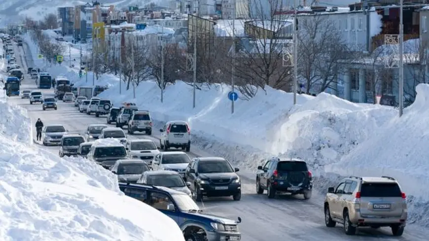
Kamchatka is digging out from a historic stretch of winter weather after successive storms dumped extraordinary snowfall across the Russian Far East, turning streets into canyons, burying vehicles, and forcing daily life in the regional capital into survival logistics. In Petropavlovsk-Kamchatsky, snowbanks climbed to window height in places, building entrances disappeared behind drifts, and residents carved narrow corridors just to reach roads that were barely passable.
While the peninsula is no stranger to harsh winters, this January 2026 episode stands out for the sheer volume and persistence of snow, with December already delivering exceptional totals and early January adding another punishing layer. The result is not just inconvenience—it’s a cascading strain on transportation, emergency response, public services, and the basic ability to move people and supplies through a city.
What’s happening in Kamchatka: a winter storm pattern that won’t let up
The current situation is being driven by a parade of low-pressure systems that repeatedly reload moisture and wind into the region. Each new pulse piles onto the previous one, making every additional centimeter more disruptive than the last because there’s nowhere to put it: cleared snow gets re-buried, plowed lanes narrow further, and the weight on roofs increases.
In practical terms, the storm sequence has created three simultaneous problems:
-
Accumulation that outpaces snow removal capacity
-
Strong winds that redistribute snow into deep, dense drifts
-
Secondary hazards from the weight and instability of snow on rooftops and around buildings
Even when snowfall eases temporarily, the recovery window is short. The next band arrives before the system can fully reset.
Petropavlovsk-Kamchatsky under pressure: transport, schools, and daily life
The greatest disruption is concentrated in and around Petropavlovsk-Kamchatsky, where mobility becomes the limiting factor for everything else. When roads narrow to single lanes and intersections become chokepoints, public transport falters, deliveries slow, and emergency vehicles struggle to reach calls quickly.
Common impacts seen during the heaviest phase of the storms include:
-
Widespread interruptions to local transit routes
-
Temporary closures or disruptions to schools and municipal services
-
Delays and cancellations affecting air travel and regional connections
-
Increased reliance on heavy equipment and specialized vehicles to move through deep drifts
For many households, the workday starts with digging: clearing doors, stairwells, vents, and access paths before any commute is even possible.
The hidden danger: roof snow, falling ice, and the power-outage risk
The most dangerous part of extreme snow events often isn’t the snowfall itself—it’s what happens after it accumulates. Wet, heavy snow can load roofs unevenly, creating collapse risks or sudden “roof avalanches” when temperatures fluctuate or wind shifts the snowpack.
Key safety hazards in these conditions:
-
Falling snow and ice from rooftops and awnings
-
Blocked exits and stairwells, especially in multi-story buildings
-
Limited visibility at intersections and crosswalks due to towering plow piles
-
Power interruptions if lines are stressed by ice, wind, or falling debris
Local authorities typically emphasize staying clear of building edges, avoiding parked vehicles under eaves, and treating any cracking sounds or sagging structures as immediate warning signs.
How extreme is it? The numbers behind January 2026 snowfall
Weather monitoring in the region indicates that December delivered snowfall well above typical monthly levels, and early January added another substantial round, compounding the depth on the ground. The most striking feature isn’t a single “one-day” record, but the multi-week cumulative load—enough to swallow cars, obscure lower floors of buildings behind drifts, and create snow walls that behave like temporary terrain.
A simple snapshot of what that means on the ground:
-
Snow removal becomes a constant operation rather than a cleanup
-
Piled snow restricts sightlines and roadway width day after day
-
The risk of injuries rises as people shovel repeatedly in difficult conditions
-
Supply chains become fragile if even one key corridor is blocked
What happens next: when Kamchatka can realistically recover
Recovery depends on two things: a break in the storm train and a period of stable weather that allows crews to widen roads, clear critical infrastructure, and safely remove roof loads. Without that pause, the region stays in a defensive posture—clearing just enough to keep essential movement going.
In the near term, priorities tend to follow a predictable order:
-
Emergency access routes and medical response lanes
-
Main arterial roads and public transport corridors
-
Building entrances, schools, and essential utilities
-
Residential side streets and parking areas
If additional storms arrive before those steps are completed, the city can slip back into gridlock quickly.
Why this Kamchatka winter matters beyond the peninsula
Kamchatka’s ordeal is a vivid example of how compounding weather events can overwhelm even winter-adapted communities. When snow totals stack across weeks, the question shifts from “How bad is the storm?” to “How long can systems function at reduced capacity?”
For residents, the focus remains immediate: safe movement, reliable heat and power, accessible roads, and a careful eye on roofs and overhangs. For the region, the next few days are about finding a weather window long enough to turn emergency response into real recovery.


