


Winter Storm Watch Expands Ahead of Late-Week Snow and Ice Threat Across a Broad U.S. Corridor
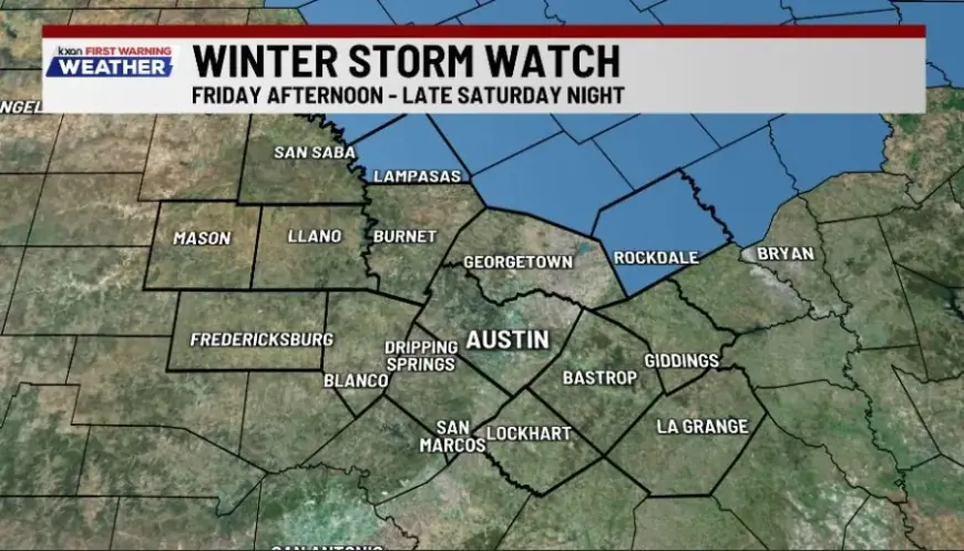
A growing number of communities are under a Winter Storm Watch as a late-week system lines up to deliver a dangerous mix of snow, sleet, and freezing rain—especially from parts of the South and Plains into the lower Midwest and toward the Southeast. The watch signals conditions are becoming favorable for significant winter impacts, even if exact totals and the storm track are still coming into focus.
The biggest concern isn’t just snow depth. It’s ice. Even modest ice accretion can snap tree limbs, pull down power lines, and turn roads into skating rinks for days—particularly if temperatures stay below freezing after the precipitation ends.
What a Winter Storm Watch Means Right Now
A Winter Storm Watch is an early heads-up: impactful winter weather is possible in the watch area, usually within the next 24 to 48 hours (sometimes a bit longer). It’s not a guarantee that the worst-case scenario will happen everywhere in the watch zone, but it’s a strong signal to start planning for real disruptions.
Over the next couple of days, many watch areas can shift into warnings or advisories as confidence increases. The watch map can also expand or slide north/south as forecasters refine where the heaviest snow bands and the most damaging icing set up.
Where the Highest-Risk Impacts Are Setting Up
Recent updates point to a wide swath where wintry precipitation could become significant, with the highest-impact zone often lining up near the boundary between deep cold air and moist Gulf air. That “battle line” is where freezing rain and sleet tend to maximize—often producing the most travel trouble and the greatest power-outage risk.
Key themes emerging across multiple forecast areas:
-
Southern Plains into the mid-South: Higher odds of sleet and freezing rain mixing in, plus rapid changes in road conditions.
-
Lower Mississippi Valley into parts of the Southeast: A notable ice threat if the warm layer aloft pushes in while surface temperatures remain below freezing.
-
Interior sections farther north: Heavier snow potential where precipitation falls entirely as snow, with blowing snow possible if winds ramp up.
Because the storm’s exact track matters so much, two towns an hour apart can see very different outcomes—one buried in snow, the other coated in ice.
Timing: When Conditions Could Deteriorate Fast
While local timelines vary, the broad window that’s drawing the most attention begins late Friday and continues through the weekend.
Here’s a simplified timeline to watch:
-
Friday, January 23, 2026: Cold air deepens; wintry precipitation begins in parts of the watch area.
-
Saturday, January 24, 2026: Peak disruption risk in many locations—especially where freezing rain or sleet is involved.
-
Sunday, January 25, 2026: Precipitation may shift east/northeast, but hazardous travel can linger where ice remains on untreated surfaces.
The after-effect often becomes the story: refreezing at night, shaded roads staying slick, and cleanup slowed by persistent cold.
Why Ice Is the Headline Hazard
Snow creates problems; ice multiplies them.
Freezing rain is especially disruptive because it bonds to surfaces—roads, sidewalks, trees, power lines, vehicles. If icing becomes widespread:
-
Power outages can spike quickly, especially where wind adds stress to ice-loaded lines and branches.
-
Road travel can become unsafe even for plows and emergency vehicles.
-
Air travel faces cascading delays when major hubs in the South and central U.S. get hit by freezing precipitation.
Ice also makes recovery slower. If temperatures stay well below freezing, roads may not improve much during daylight hours, and melted slush can refreeze each night.
What to Do While You’re Under a Winter Storm Watch
If your area is under a Winter Storm Watch, treat it like a countdown—especially if you rely on driving for work, have medical needs, or live in a spot prone to outages.
Practical steps that matter most:
-
Plan for power loss: Charge devices, gather flashlights/batteries, and set aside blankets and shelf-stable food.
-
Prep your car: Full tank, windshield fluid rated for freezing temps, scraper, and a small emergency kit.
-
Reduce last-minute errands: Do groceries and prescriptions early; weekend conditions can deteriorate quickly.
-
Protect pipes and pets: Know where your shutoff is; bring pets inside and limit time outdoors.
-
Check neighbors and family: Especially older adults or anyone who uses powered medical equipment.
If you must travel, identify a “no-go” threshold ahead of time—ice is where even short trips can become high risk.
What Happens Next
Expect frequent updates as the storm approaches. Watch areas can tighten, expand, or shift, and local officials may adjust school schedules and event plans if confidence increases in heavy snow or damaging ice.
The key takeaway: a Winter Storm Watch is your early warning that disruptions are plausible, not a promise of exact totals. With snow and ice in the mix—and cold air likely lingering—preparing early is the safest move.