New Map Unveils U.S. Groundwater Levels
New insights into the groundwater levels in the United States have emerged from a groundbreaking study led by researchers at Princeton University and the University of Arizona. Their innovative map reveals detailed estimates of groundwater depths across the continental U.S., addressing concerns related to water scarcity and contamination.
New Map Unveils U.S. Groundwater Levels
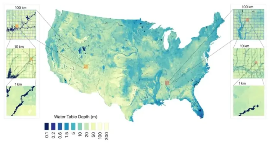
The research team combined over one million direct measurements of groundwater depth with advanced artificial intelligence techniques. This resulted in a highly detailed map that estimates groundwater depth at a resolution of approximately 30 meters (98 feet).
Key Findings
- Total groundwater volume in the U.S. is estimated at 306,000 cubic kilometers.
- This volume surpasses 13 times that of all the Great Lakes combined.
- The map identifies previously unknown shallow groundwater supplies.
Reed Maxwell, a senior author and professor at Princeton University, emphasizes the importance of this mapping effort. Historically, much of the data regarding groundwater has been vague, coming primarily from indirect sources such as rainfall and evaporation studies. Understanding actual groundwater availability is essential for effective irrigation, conservation, and resource management.
Methodology
The research utilized direct measurements collected from groundwater monitoring wells by the United States Geological Survey, spanning from 1895 to 2023. Previous studies were integrated to enhance the data, allowing for a comprehensive understanding of groundwater depths.
The continental U.S. was divided into a grid of more than 8 billion squares, each measuring 30 meters per side. This approach enabled precise assessments of groundwater depth and volume calculations based on the porosity of rocks and sediments.
Technological Innovations
While traditional models relied heavily on physics-based equations, this study employed a data-driven, AI-based model to achieve unprecedented spatial resolution. The new methodology is not only more efficient, using less computational power, but it also quantifies the uncertainty of groundwater depth estimates.
The research was published on January 14 in the journal Communications Earth & Environment. The findings are expected to have significant implications for agricultural practices, particularly in regions that rely heavily on groundwater for irrigation.
Future Implications
As Maxwell notes, understanding the availability and accessibility of groundwater is crucial for farmers and regional decision-makers. The high-resolution data will guide local decisions regarding irrigation, especially in areas where center-pivot irrigation is prevalent.
Additionally, efforts are underway to expand this research globally. Collaborations with hydrologists in Europe and Australia aim to adapt the developed models to regions with varying data availability.
The outputs from this study are accessible through the HydroFrame platform, fostering wider engagement from researchers, policymakers, and agricultural stakeholders. This collaborative approach ensures that the insights gained from this investigation will serve critical management needs in water resource planning.