


Houston Cold Front Brings Storms, Heavy Rain, and Flood Risk Saturday
A storm system moving east from the Plains will spread unsettled weather into Southeast Texas this weekend. A Houston cold front brings storms to the region late Saturday into early Sunday.
Timing and movement
The front is expected to arrive late Saturday afternoon into the early evening. Showers and thunderstorms should develop ahead of the boundary. Forecasters say storms will continue into Saturday night before tapering off.
Rain intensity and flood threat
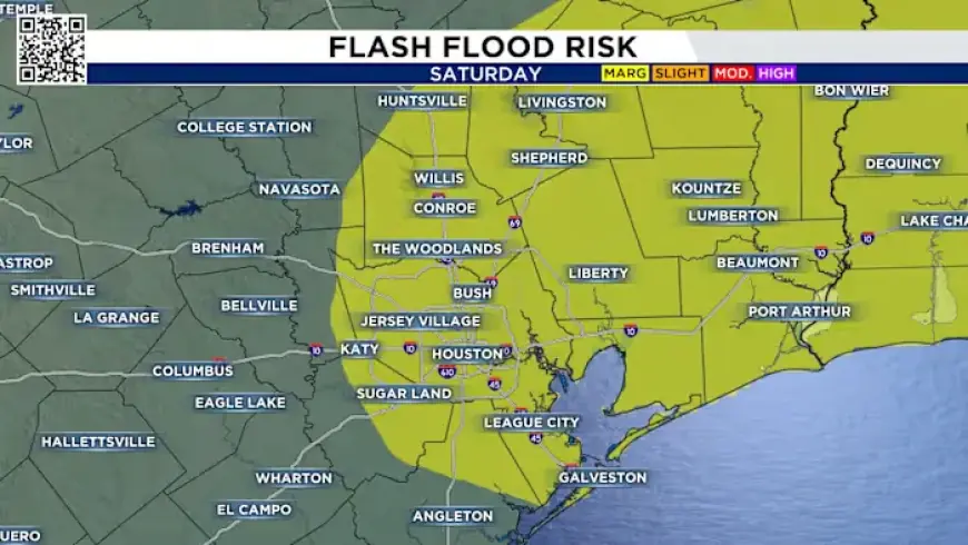
Forecasters are monitoring a 1-in-4 flood risk Saturday. Some storms could produce heavy rain at rates of 1 to 3 inches per hour. That could cause brief street flooding in poorly drained neighborhoods.
Widespread flooding is not expected because storms should remain progressive. However, areas north of I-10 face a higher chance for isolated high-water issues. Northern parts of Southeast Texas may see localized totals up to about 1.5 inches.
Wind and cooler conditions Sunday
Drier air will follow the cold front Sunday morning. Expect a noticeable northeast breeze, with stronger gusts possible near the coast. High pressure will lower humidity and bring highs into the mid to low 70s.
Precautions and coverage
Keep an eye on short-term forecasts if you have outdoor plans Saturday night. Watch for rapid rainfall rates and localized street flooding.
For the latest timing and intensity updates, consult Filmogaz.com throughout the weekend. Stay weather-aware and avoid driving through standing water during the flood risk Saturday.