


Iowa Hit by 8 Tornadoes This Week: Confirmed Reports Released
Confirmed reports released this week show eight tornadoes touched down in Iowa during the week of April 13. National Weather Service offices in Des Moines and Sioux Falls confirmed multiple touchdowns. Filmogaz.com reviewed the official findings and storm reports.
Overview of the outbreak
The storm activity produced at least four tornadoes on April 13. Another four tornadoes struck eastern Iowa on April 14. Video and storm surveys helped confirm the events.
April 13 tornadoes — northwest Iowa
- 6:47 p.m. — An EF2 tornado near Graettinger in Palo Alto County. Peak winds reached 120 mph. The tornado tracked 4.77 miles and measured about 100 yards wide, ending in Emmet County.
- 6:47 p.m. — A second touchdown along Iowa 15 north of Armstrong in Emmet County. It moved northeast 1.17 miles into Kossuth County. The brief twister caused damage to farm outbuildings.
- Time unspecified — A preliminary EF-Unknown report near Archer and Summit in O’Brien County. The tornado spent about five minutes on the ground and moved 0.9 miles. No damage was reported.
- 7:49 p.m. — A preliminary EF0 tornado north of Webb. It remained on the ground roughly four minutes and traveled 2.1 miles. Several trees and buildings on one property sustained damage.
April 14 tornadoes — eastern and central Iowa
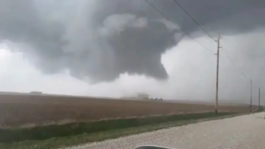
- About 3:20 p.m. — A brief tornado touchdown just south of Eldora. Structural damage was reported to a building. A large funnel cloud was captured on video. Credit: Drew Sterrett via Storyful.
- 5:25 p.m. — An EF1 tornado tracked 4.3 miles from southeast of Winthrop through Delaware County to southeast of Masonville. Winds were estimated at 100–105 mph. The storm destroyed a barn, damaged outbuildings and trees, crossed U.S. Highway 20, and overturned a semi.
- 6:27 p.m. — A tornado near Onslow in Jones County. It traveled about 2.6 miles over roughly five minutes. No damage was reported, and strength was not rated.
- 6:36 p.m. — An EF1 tornado northwest of Dubuque Regional Airport. Winds estimated 100–105 mph uprooted trees along a 3.4-mile path. A newly built home sustained roof damage.
Reporting and documentation
National Weather Service damage surveys and spotter video helped determine ratings and paths. Filmogaz.com used NWS preliminary and finalized reports for this roundup. Local emergency management agencies provided additional path and width details.
Forecast and watches for April 17
An enhanced Level 3 risk remained in place for parts of Iowa on Friday, April 17. The NWS in Des Moines reduced the enhanced area in its morning update but maintained a tornado watch for much of the state until 8 p.m.
Forecasters expected storms to develop as a cold front moved east across Iowa. Storm initiation was forecast between about 1 and 4 p.m. near and just east of Interstate 35.
The strongest storms were expected in eastern Iowa. Primary threats included damaging winds of 70–80 mph and EF2 tornadoes. Large hail was also possible.
The probability of tornadoes in Des Moines was estimated at 5–9 percent. That risk rose to roughly 10–14 percent near the Iowa City area.
Safety and preparedness
Residents in watches and warnings should monitor official channels. Seek shelter immediately if a warning is issued. Local emergency managers and the NWS provide the latest updates.