


Metro Detroit Faces Intense Heat and Multiple Storms
A 4Warn Weather Alert is in effect across Southeast Michigan for Tuesday evening into Wednesday morning. Meteorologists warn of strong storms and localized flooding in urban and low-lying areas.
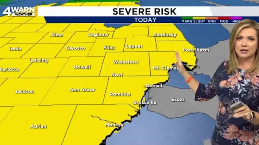
Alert details
All of Southeast Michigan sits under a slight, level 2 risk for severe thunderstorms. Storms could bring wind gusts up to 60 mph and large hail.
Forecasters say isolated tornadoes are possible. Flooding is a significant concern due to heavy rainfall rates.
Timing and rainfall
The primary window for severe storms is mainly between 8 pm and 2 am. Heavy rain will continue into Wednesday morning.
Forecast totals tonight through Wednesday night average about 1.5 inches. Some localized spots could see 2 to 4 inches, increasing flood risk.
Local impacts and safety
- Urban and low-lying neighborhoods face the highest flooding threat.
- Expect downed branches and possible power outages from strong gusts.
- Do not drive through flooded roadways. Turn around, don’t drown.
Short-term outlook
A brief dry spell arrives today with highs near 80 degrees. Metro Detroit faces intense heat and multiple storms this week.
Temperatures remain warm, with highs in the 70s and low 80s through much of the week. Scattered storms are possible again on Thursday.
Friday should be drier. A stronger storm threat appears Saturday as a cold front approaches.
That front will cut temperatures by nearly 20 degrees on Sunday. Expect high temperatures to fall into the 50s.
About the forecast
This forecast and alert were prepared by Ashlee Baracy. She is an Emmy award-winning meteorologist born and raised in Metro Detroit.
You can catch her 4Warn Weather forecasts weekday mornings, at noon, and streaming on Local4+.
Copyright 2026 by Filmogaz.com – All rights reserved.