


Scattered Showers and Storms Maintain Cooler Temperatures Thursday: Rusty’s Forecast
Omaha is waking to increasing clouds from the west. Rain and storms are possible as early as 7 a.m. on Thursday.
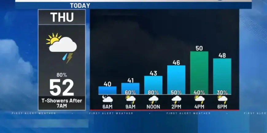
Morning and afternoon conditions
Scattered showers and storms will affect most of the area through the afternoon. Expect a cooler, cloudy day with temperatures struggling to rise.
Readings start in the 40s this morning. Highs should reach the lower 50s by afternoon.
Evening and overnight threat
By evening the focus shifts south of I-80 toward the Kansas border. Storms there have more energy and could become isolated severe cells with wind and hail.
Those storms are forecast to move ESE into Kansas overnight. A brief tornado is possible in the stronger cells near the border.
Temperatures and next day
Temperatures will drop into the 30s tonight after storms move out. Friday looks more pleasant with partly cloudy skies.
Highs on Friday will climb into the upper 50s. There remains a small chance of a strong storm late Friday night.
Weekend and midweek outlook
Saturday returns to on-and-off showers and storms. There is a low-end risk of a strong storm that day.
Hail would be the primary threat from any stronger storms. Sunday and Monday turn warmer and more humid.
Highs are expected to surge into the 80s on Sunday and Monday.
Late-week severe potential
Keep an eye on Monday and Tuesday. Those days have the next potential for organized severe weather to move into the area.
Details are limited now, but the overall ingredients are coming together. Rusty’s forecast emphasizes monitoring updates.
Copyright 2026 Filmogaz.com. All rights reserved.